Pressath | |
|---|---|
 Coat of arms | |
Location of Pressath within Neustadt a.d.Waldnaab district 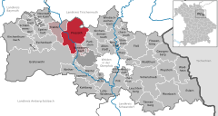 | |
 Pressath  Pressath | |
| Coordinates: 49°46′N 11°55′E / 49.767°N 11.917°E | |
| Country | Germany |
| State | Bavaria |
| Admin. region | Oberpfalz |
| District | Neustadt a.d.Waldnaab |
| Municipal assoc. | Pressath |
| Government | |
| • Mayor (2020–26) | Bernhard Stangl [1] ( SPD) |
| Area | |
| • Total | 66.31 km2 (25.60 sq mi) |
| Elevation | 435 m (1,427 ft) |
| Population (2022-12-31)
[2] | |
| • Total | 4,289 |
| • Density | 65/km2 (170/sq mi) |
| Time zone | UTC+01:00 ( CET) |
| • Summer ( DST) | UTC+02:00 ( CEST) |
| Postal codes | 92690 |
| Dialling codes | 09644 |
| Vehicle registration | NEW |
| Website | www.pressath.de |
Pressath is a municipality in the district of Neustadt an der Waldnaab, in Bavaria, Germany. Pressath was founded in 1657. It is situated 20 km northwest of Weiden in der Oberpfalz and ca. 7 km north of Grafenwöhr.
References
- ^ Liste der ersten Bürgermeister/Oberbürgermeister in kreisangehörigen Gemeinden, Bayerisches Landesamt für Statistik, 15 July 2021.
- ^ Genesis Online-Datenbank des Bayerischen Landesamtes für Statistik Tabelle 12411-003r Fortschreibung des Bevölkerungsstandes: Gemeinden, Stichtag (Einwohnerzahlen auf Grundlage des Zensus 2011) ( Hilfe dazu).

| International | |
|---|---|
| National | |
|
| This Neustadt (Waldnaab) district location article is a stub. You can help Wikipedia by expanding it. |
You can help expand this article with text translated from
the corresponding article in German. (April 2018) Click [show] for important translation instructions.
|