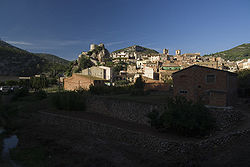
Pratdip | |
|---|---|
 Pratdip | |
| Coordinates: 41°3′11″N 0°52′20″E / 41.05306°N 0.87222°E | |
| Country | Spain |
| Autonomous community | Catalonia |
| Province | Tarragona |
| Comarca | Baix Camp |
| Government | |
| • mayor | Joan Ma. Rovira Vernet (2015) [1] |
| Area | |
| • Total | 36.3 km2 (14.0 sq mi) |
| Elevation | 245 m (804 ft) |
| Population (2018)
[3] | |
| • Total | 709 |
| • Density | 20/km2 (51/sq mi) |
| Demonym(s) | Pratdipenc, pratdipenca |
| Website |
www |
Pratdip (Catalan pronunciation: [ˌpɾadˈdip]) is a municipality in the comarca of Baix Camp, in the province of Tarragona, Catalonia, Spain.
Most of the people of Pratdip work in agriculture in the pastures, fields, and forests around the village. Prominent local agricultural products are hazelnuts and almonds.
History
The oldest documents that refer to Pratdip by name are papal bulls of Pope Anastasius IV in 1154.
In medieval times the town was part of the Barony of Entença.
References
- ^ "Ajuntament de Pratdip". Generalitat of Catalonia. Retrieved 2015-11-13.
- ^ "El municipi en xifres: Pratdip". Statistical Institute of Catalonia. Retrieved 2015-11-23.
- ^ Municipal Register of Spain 2018. National Statistics Institute.
- Panareda Clopés, Josep Maria; Rios Calvet, Jaume; Rabella Vives, Josep Maria (1989). Guia de Catalunya, Barcelona: Caixa de Catalunya. ISBN 84-87135-01-3 (Spanish). ISBN 84-87135-02-1 (Catalan).
External links
Wikimedia Commons has media related to
Pratdip.
41°03′N 0°52′E / 41.050°N 0.867°E

