| Port of Pori | |
|---|---|
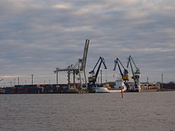
 Mäntyluoto harbour | |
|
Click on the map for a fullscreen view | |
| Location | |
| Country | Finland |
| Coordinates | 61°35′N 21°29′E / 61.583°N 21.483°E |
| UN/LOCODE | FIPOR [1] [2] |
| Details | |
| No. of berths | 23 [2] |
| Draft depth | 15.3m [2] |
| Statistics | |
| Website www | |
Port of Pori ( Finnish: Porin satama) is a complex of three harbours. It is by the Gulf of Bothnia in Pori, Finland. The port authority of Pori was established in 1780. Today the Port of Pori is a corporation owned by the city.
Port of Pori has liner service to several ports in Northern Europe, for example Hamburg, Ghent, St. Petersburg and Teesport.
Mäntyluoto
Mäntyluoto harbour has docks for container traffic and dry bulk. Crane capacity is up to 200 tonnes (200 long tons; 220 short tons). The 200-ton crane Masa is the strongest in Finnish ports. The maximum allowed draught in Mäntyluoto is 12.0 metres (39.4 ft).
Tahkoluoto
The Tahkoluoto bulk harbour has 15.3-metre (50 ft) draught which allows access for capesize vessels. [2] Oil and chemical harbour operates in a separate area.
See also
References
- ^ "UNLOCODE (FI) - FINLAND". service.unece.org. Retrieved 19 February 2021.
- ^ a b c d "Port of Pori, Finland". www.findaport.com. Shipping Guides Ltd. Retrieved 19 February 2021.
External links
![]() Media related to
Port of Pori at Wikimedia Commons
Media related to
Port of Pori at Wikimedia Commons