| Port of Izmail | |
|---|---|
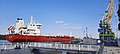
 Izmail sea trade port - view from the fortress, 2014. | |
|
Click on the map for a fullscreen view | |
Native name | Ізмаїльський морський порт |
| Location | |
| Country | |
| Location | Izmail, Izmail Raion, Odessa Oblast |
| Coordinates | 45°20′20.8″N 28°47′50.5″E / 45.339111°N 28.797361°E |
| Details | |
| Opened | 1813 |
| Size | 107.5 hectares |
| Head of the seaport administration | Serhiy Ivanovych Laponoh |
| Statistics | |
| Website izmport.com.ua | |
Izmail Sea Commercial Port, a state-owned enterprise in the field of maritime transport, is a multidisciplinary port located in the waters of the Kiliia River estuary [1] of the Danube. [2] It reports to the Ministry of Infrastructure (Ukraine). [3] It is an important transport hub of Ukraine. According to the Law of Ukraine "On Seaports of Ukraine," the functions of the seaport administration are performed by the Izmail branch of the state enterprise of the Ukrainian Sea Ports Authority (AMPU). [4] The number of employees at Port of Izmail as of 2009 was 2,520 people.
Gallery
-
 Usichem tanker, Izmail Seaport, June, 2020.
 -
 Port of Izmail main entrance, September, 2014.
 -
 Port of Izmail, panorama, August, 2008.


See also
References
- ^ "Port of Izmayil (Izmail), Ukraine". ports.com. Retrieved April 7, 2022.
- ^ "Izmail Sea Commercial Port Raised USD 1 Billion Credit Facility from FUIB". pumb.ua. 18 December 2012. Retrieved April 7, 2022.
- ^ "Georgian company interested in Izmail port". odessa-journal.com. The Odessa Journal. March 29, 2021. Retrieved April 7, 2022.
- ^ "Ізмаїльський морський торговельний порт (Izmail sea commercial port)". esu.com.ua. Енциклопедія Сучасної України - Encyclopedia of Modern Ukraine. Retrieved April 7, 2022.
| Black Sea | ||
|---|---|---|
| Azov Sea | ||
| River | ||
| Ferry | ||
|
South China Sea (owned) | ||
(*) Crimea ports are occupied by Russia | ||