-
 View of Puerto Angel's wharf
 -
 Municipal Palace, San Pedro Pochutla
 -
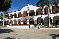
 Municipal Palace, Santa María Tonameca
 -
 Protected turtle eggs incubating in La Ventanilla
(Redirected from
Pochutla District, Oaxaca)
Pochutla District | |
|---|---|
District | |
 Oaxaca regions and districts: Costa in the southwest | |
 Pochutla District  Pochutla District | |
| Coordinates: 15°44′N 96°28′W / 15.733°N 96.467°W | |
| Country | |
| State | Oaxaca |
| Region | Costa |
| Area | |
| • Total | 3,773.29 km2 (1,456.88 sq mi) |
| Population (2010) | |
| • Total | 199,251 |
Pochutla District is located in the east of the Costa Region of the State of Oaxaca, Mexico. The primary city is San Pedro Pochutla. [1]
Municipalities

The district includes the following municipalities: [1]
Images of Pochutla District


References
- ^ a b "Enciclopedia de los Municipios de México: Estado de Oaxaca". Retrieved 2010-07-08.
|
| This article about a location in the Mexican state of Oaxaca is a stub. You can help Wikipedia by expanding it. |