| Pleasanton Ridge Regional Park | |
|---|---|
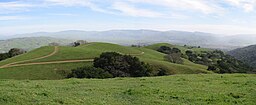
 View looking south along the ridge from one of the peaks | |
| Location | Pleasanton, California |
| Coordinates | 37°36′55″N 121°53′04″W / 37.6154094°N 121.8845595°W |
| Area | 5,271-acre (21.33 km2) |
| Created | 1988 |
| Operated by | East Bay Regional Park District |
Pleasanton Ridge Regional Park is a 5,271-acre (21.33 km2) park in the East Bay Regional Park District overlooking Pleasanton, California and the Livermore Valley to the east. The park is scheduled to grow by almost 1,500 acres (6.1 km2) (sic) with the acquisition of the Tyler Ranch. [1]
History
Pleasanton Ridge Regional Park, located west of the I-680 freeway and the City of Pleasanton, California, became a reality in 1988, when the East Bay Regional Park District bought 1,700 acres (6.9 km2) to start what would become its second-largest park. In 1980, a real estate developer had proposed building a golf course and a number of new homes atop Pleasanton Ridge. A large number of area residents opposed the proposal and defeated it in a referendum in 1983. [2]
In 2012, the park district announced it had purchased 1,367 acres (5.53 km2) from Robertson Ranch, east of Palomares Road, which it would add to Pleasanton Ridge Regional Park. The tract included the landmark Sunol Peak (elevation 2,163 feet (659 m). The price was reported as $6.2 million. The report stated that prior to the purchase, the regional park contained 7,500 acres (30 km2) of land. [3]
Tyler Ranch acquisition
The Tyler Ranch extends for about 3.5 miles (5.6 km) along Sunol Ridge. [a] The north end of the ranch abutted the existing Pleasanton Ridge park at the end of Kilkare Road. It also has good access from Foothill Road. The acquisition was supported by the Priem Family Foundation, which is dedicated to preserving open space in the greater Bay Area. [4]
EBRPD claimed that the Tyler Ranch acquisition marked the occasion when the district acquired 100,000 acres since it was formed in 1934. [5]
Trails
Pleasanton Ridge Regional Park contains over 25 miles (40 km) of trails, most of which are dirt roads, except for the Woodland Trail, the Bay Leaf Trail, and a few sections of the North Ridge and Ridgeline trails. Park elevations range from 400 feet (120 m) at the main entrance to over 1,600 feet (490 m) at the highest point. [6]
Adjacent to the park is the Augustin Bernal Park.


Notes
- ^ The area actually acquired totalled 1,476 acres (5.97 km2), bringing the size of the expanded park to 6,146 acres (24.87 km2).
References
- ^ Valley Sentinel News, Bev Lane, 1 November 2007
- ^ Cuff, Denis. "Park with a view: Pleasanton Ridge expands fast." East Bay Times. September 6, 2013. Updated July 20, 2016. Accessed August 17, 2017.
- ^ Austin, Michael. "Another Major Land Purchase on the Pleasanton Ridge by East Bay Regional Parks District." Pleasanton Patch. August 18, 2012. Accessed August 17, 2017.
- ^ Mackay, Ned. "Tyler Ranch to join district." East Bay Times. October 5, 2007. Updated August 15, 2016 Accessed August 16, 2017.
- ^ Baciagalupi, Bob. "The 100,000th Acre for East Bay Parks." Bay Nature. January 12, 2010. Accessed August 16, 2017
- ^ "Pleasanton Ridge Regional Park (and Augustin Bernal Community Park). Trailstompers. Accessed September 11, 2017.


