Pleasant Grove | |
|---|---|
 Pleasant Grove Location of the community of Pleasant Grove within Pleasant Grove Township, Olmsted County  Pleasant Grove Pleasant Grove (the United States) | |
| Coordinates: 43°52′09″N 92°23′09″W / 43.86917°N 92.38583°W | |
| Country | United States |
| State | Minnesota |
| County | Olmsted |
| Township | Pleasant Grove Township |
| Elevation | 1,289 ft (393 m) |
| Time zone | UTC-6 ( Central (CST)) |
| • Summer ( DST) | UTC-5 (CDT) |
| ZIP code | 55976 |
| Area code | 507 |
| GNIS feature ID | 649549 [1] |
Pleasant Grove is an unincorporated community in Pleasant Grove Township, Olmsted County, Minnesota, United States, near Rochester and Stewartville. The community is located along Olmsted County Road 1 near County Road 140.
History
Pleasant Grove was platted in 1854, and named for a grove of oak trees near the original town site. [2] A post office was established at Pleasant Grove in 1854, and remained in operation until 1905. [3]
Notable person
- Augustus Barrows (1838–1885), lumberman and legislator
| Census | Pop. | Note | %± |
|---|---|---|---|
| 1880 | 200 | — | |
| U.S. Decennial Census [4] | |||
References
- ^ "Pleasant Grove, Minnesota". Geographic Names Information System. United States Geological Survey, United States Department of the Interior.
- ^ Upham, Warren (1920). Minnesota Geographic Names: Their Origin and Historic Significance. Minnesota Historical Society. p. 387.
- ^ "Olmsted County". Jim Forte Postal History. Retrieved July 27, 2015.
- ^ United States Census Bureau. "Census of Population and Housing".
Municipalities and communities of
Olmsted County, Minnesota, United States | ||
|---|---|---|
| Cities | 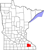 | |
| Townships | ||
| CDPs | ||
|
Unincorporated communities | ||
| Footnotes | ‡This populated place also has portions in an adjacent county or counties | |
| International | |
|---|---|
| National | |