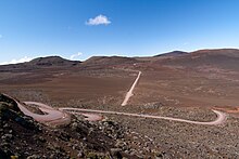
The Plaine des Sables (English: "Sands Plain") is a volcanic plateau in the mountains of Réunion. Part of the Piton de la Fournaise massif, this volcanic desert is situated at the border of Saint-Joseph and Sainte-Rose, within Réunion National Park. [1] [2]
References
- ^ "Plaine des Sables". Discover Reunion. Retrieved 10 September 2021.
- ^ "Plaine des sables". Cartedelareunion.fr. Retrieved 10 September 2021.
Wikimedia Commons has media related to
Plaine des Sables.
21°13′48″S 55°39′36″E / 21.23000°S 55.66000°E