Phitsanulok Airport ท่าอากาศยานพิษณุโลก | |||||||||||
|---|---|---|---|---|---|---|---|---|---|---|---|
_%E0%B8%97%E0%B9%88%E0%B8%B2%E0%B8%AD%E0%B8%B2%E0%B8%81%E0%B8%B2%E0%B8%A8%E0%B8%A2%E0%B8%B2%E0%B8%99%E0%B8%9E%E0%B8%B4%E0%B8%A9%E0%B8%93%E0%B8%B8%E0%B9%82%E0%B8%A5%E0%B8%81_-_IMG_02.jpg) | |||||||||||
| Summary | |||||||||||
| Airport type | Public | ||||||||||
| Owner | Royal Thai Air Force | ||||||||||
| Operator | Department of Airports | ||||||||||
| Serves | Phitsanulok, Phitsanulok province, Thailand | ||||||||||
| Opened | 1941 | ||||||||||
| Elevation AMSL | 154 ft / 47 m | ||||||||||
| Coordinates | 16°46′23″N 100°16′56″E / 16.77306°N 100.28222°E | ||||||||||
| Maps | |||||||||||
|
| |||||||||||
 PHS/VTPP Location of airport in Thailand | |||||||||||
|
| |||||||||||
| Runways | |||||||||||
| |||||||||||
| Statistics (2023) | |||||||||||
| |||||||||||
Phitsanulok Airport ( IATA: PHS, ICAO: VTPP) is an airport serving Phitsanulok, a city in the Phitsanulok province of northern Thailand. The airport is south of the city's downtown area.
Airlines and destinations
In 2019 it handles 689,392 passengers, 5,661 flights and 150,980 kilograms (332,850 lb) of cargo. [3]
| Airlines | Destinations |
|---|---|
| Nok Air | Bangkok–Don Mueang |
| Thai AirAsia | Bangkok–Don Mueang |
| Thai Lion Air | Bangkok–Don Mueang |
Miscellaneous
To the right and to the left of the tarmac are two decommissioned Boeing 747 jets from Orient Thai Airlines. The airline ceased operations and filed for bankruptcy in October 2018.
-
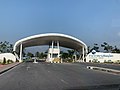 Entrance gate to Phitsanulok Airport (2022)
 -
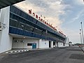 Terminal of Phitsanulok Airport (2022)
 -
 Nok-Air Boeing 737-400 at Phitsanulok (2011)
 -
 Decommissioned Orient Thai Airlines Boeing 747 (2011)
 -
 Phitsanulok Airport check in counters (2019)
_%E0%B8%97%E0%B9%88%E0%B8%B2%E0%B8%AD%E0%B8%B2%E0%B8%81%E0%B8%B2%E0%B8%A8%E0%B8%A2%E0%B8%B2%E0%B8%99%E0%B8%9E%E0%B8%B4%E0%B8%A9%E0%B8%93%E0%B8%B8%E0%B9%82%E0%B8%A5%E0%B8%81_-_IMG_16.jpg)
_%E0%B8%97%E0%B9%88%E0%B8%B2%E0%B8%AD%E0%B8%B2%E0%B8%81%E0%B8%B2%E0%B8%A8%E0%B8%A2%E0%B8%B2%E0%B8%99%E0%B8%9E%E0%B8%B4%E0%B8%A9%E0%B8%93%E0%B8%B8%E0%B9%82%E0%B8%A5%E0%B8%81_-_IMG_03.jpg)
_at_Phitsanulok_Airport.jpg)

Notes
References
-
^
"Airport information for VTPP". World Aero Data. Archived from the original on 2019-03-05.
{{
cite web}}
: CS1 maint: unfit URL ( link) Data current as of October 2006. Source: DAFIF. - ^ Airport information for PHS at Great Circle Mapper. Source: DAFIF (effective October 2006).
- ^ Phitsanulok Provincial Statistical Report 2562-2019: Statistics of Domestic Air Transport:2019. Phitsanulok Provincial Statistical Office (Report). National Statistical Office (NSO). 2020. p. 147. ISSN 1905-8314.
External links
-
 Phitsanulok travel guide from Wikivoyage
 - Phitsanulok Airport, Dept of Civil Aviation
- Current weather for VTPP at NOAA/ NWS
- Accident history for PHS at Aviation Safety Network