Petäjävesi | |
|---|---|
Municipality | |
| Petäjäveden kunta Petäjävesi kommun | |
 | |
 Coat of arms | |
 Location of Petäjävesi in Finland | |
| Coordinates: 62°15.5′N 025°11′E / 62.2583°N 25.183°E | |
| Country | |
| Region | Central Finland |
| Sub-region | Jyväskylä sub-region |
| Charter | 1868 |
| Government | |
| • Municipal manager | Eero Vainio |
| Area (2018-01-01)
[1] | |
| • Total | 495.41 km2 (191.28 sq mi) |
| • Land | 456.42 km2 (176.22 sq mi) |
| • Water | 39.01 km2 (15.06 sq mi) |
| • Rank | 192nd largest in Finland |
| Population (2023-12-31)
[2] | |
| • Total | 3,593 |
| • Rank | 203rd largest in Finland |
| • Density | 7.87/km2 (20.4/sq mi) |
| Population by native language | |
| • Finnish | 98.4% (official) |
| • Swedish | 0.1% |
| • Others | 1.5% |
| Population by age | |
| • 0 to 14 | 18.9% |
| • 15 to 64 | 56.3% |
| • 65 or older | 24.8% |
| Time zone | UTC+02:00 ( EET) |
| • Summer ( DST) | UTC+03:00 ( EEST) |
| Website | www.petajavesi.fi |
Petäjävesi (Finnish pronunciation: [ˈpetæjæˌʋesi]; lit. "pine water") is a municipality of Finland. It is located in the province of Western Finland, next to the city of Jyväskylä, and is part of the Central Finland region. The municipality has a population of 3,593 (31 December 2023) [6] and covers an area of 495.41 square kilometres (191.28 sq mi) of which 39.01 km2 (15.06 sq mi) is water. [1] The population density is 7.87 inhabitants per square kilometre (20.4/sq mi).
Neighbouring municipalities are Jyväskylä, Jämsä, Keuruu, Multia and Uurainen.
The municipality is unilingually Finnish.
The Petäjävesi Old Church, was listed as a UNESCO World Heritage Site in 1994 for its testimony to Nordic church architecture. [7]
Nature
There are all together 99 lakes in Petäjävesi. The biggest lakes are Jämsänvesi-Petäjävesi, Ala-Kintaus and Ylä-Kintaus. Karikkoselkä is a lake in Petäjävesi, which is formed by a meteorite. [8]
The Karikkoselkä impact crater is located southeast of the municipal centre.
Notable people
- Mika Aaltola (1969–)
- Jarmo Kytölehto (1961–)
- Frans Lehtonen (1859–1920)
- Olavi Tupamäki (1944–)
Gallery
-
 Petäjävesi Old Church interior
 -
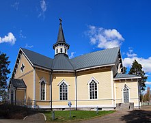 Petäjävesi New Church
 -
 Petäjävesi Old Church


References
- ^ a b "Area of Finnish Municipalities 1.1.2018" (PDF). National Land Survey of Finland. Retrieved 30 January 2018.
- ^ "Immigration record high in Finland in 2023". StatFin. Statistics Finland. Retrieved 25 January 2024.
- ^ "Demographic Structure by area as of 31 December 2022". Statistics Finland's PX-Web databases. Statistics Finland. Retrieved 6 September 2023.
- ^ "Population according to age (1-year) and sex by area and the regional division of each statistical reference year, 2003–2020". StatFin. Statistics Finland. Retrieved 2 May 2021.
- ^ a b "Luettelo kuntien ja seurakuntien tuloveroprosenteista vuonna 2023". Tax Administration of Finland. 14 November 2022. Retrieved 7 May 2023.
- ^ "Population by municipality as of 31 December 2006". Population Information System (in Finnish and Swedish). Population Register Center of Finland. Retrieved 2 May 2010.[ permanent dead link]
- ^ "Petäjävesi Old Church". UNESCO World Heritage Centre. United Nations Educational, Scientific, and Cultural Organization. Retrieved 25 September 2021.
- ^ "Petäjävesi (kunta)". Järviwiki. Finland's Environmental Administration. 2012. Retrieved 27 February 2012.
External links
- Municipality of Petäjävesi – Official website, finnish, english
| Municipalities | ||
|---|---|---|
| Former municipalities | ||
| International | |
|---|---|
| National | |
| Geographic | |
|
| This Western Finland location article is a stub. You can help Wikipedia by expanding it. |