This article includes a
list of references,
related reading, or
external links, but its sources remain unclear because it lacks
inline citations. (November 2009) |
Peradeniya
පේරාදෙණිය பேராதனை | |
|---|---|
suburb | |
 Peradeniya Botanical garden | |
| Coordinates: 7°16′N 80°36′E / 7.267°N 80.600°E | |
| Country | Sri Lanka |
| Province | Central Province |
| District | Kandy District |
| Population | |
| • Total | 30,000 |
| Time zone | +5.30 |
| Post Code | 20400 |
Peradeniya ( Sinhala: පේරාදෙණිය, romanized: Pēradeniya; Tamil: பேராதனை, romanized: Pērātaṉai) is a suburb of the city of Kandy, about 30,000 inhabitants in Sri Lanka. It is situated on the A1 main road, just a few kilometres west of Kandy city centre. Peradeniya is supposed to take its name from pera ( guava) and deniya (a plain). [1]
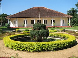
Peradeniya is famous for the Royal Botanical Gardens of Peradeniya. It is situated in a slope of the Mahaweli river and attracts many visitors from Sri Lanka as well as from abroad.
Another key attribute of this suburb is the University of Peradeniya. Its buildings are of mixed colonial and traditional Sri Lankan/South Asian styles, and located amongst the lush vegetation of the hill country. The Department of Agriculture is also located here. The Sri Lanka Telecom Training Centre is situated here.
West of the suburb lies the small historical town of Kadugannawa.
References
- ^ MacMillan, H. F. (1906). Illustrated Guide to the Royal Botanic Gardens, Peradeniya. p. 7. ISBN 9788120613539.
