Partira
Πάρτιρα | |
|---|---|
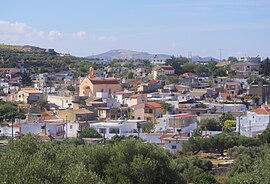
 Aerial view of the village | |
| Coordinates: 35°07′N 25°13′E / 35.117°N 25.217°E | |
| Country | Greece |
| Administrative region | Crete |
| Regional unit | Heraklion |
| Municipality | Minoa Pediada |
| Municipal unit | Arkalochori |
| Population (2021)
[1] | |
| • Community | 364 |
| Time zone | UTC+2 ( EET) |
| • Summer ( DST) | UTC+3 ( EEST) |
Partira is a village and a community in Crete. Belongs to Minoa Pediada municipality and it is located near Arkalochori in the regional unit of Heraklion. Its population is 364 (2021). The residents are engaged in rural work.
References
- ^ "Αποτελέσματα Απογραφής Πληθυσμού - Κατοικιών 2021, Μόνιμος Πληθυσμός κατά οικισμό" [Results of the 2021 Population - Housing Census, Permanent population by settlement] (in Greek). Hellenic Statistical Authority. 29 March 2024.
