Palauig | |
|---|---|
| Municipality of Palauig | |
 Downtown area | |
 Flag  Seal | |
 Map of Zambales with Palauig highlighted | |
.svg) Palauig Location within the
Philippines | |
| Coordinates: 15°26′01″N 119°54′30″E / 15.4336°N 119.9083°E | |
| Country | Philippines |
| Region | Central Luzon |
| Province | Zambales |
| District | 2nd district |
| Founded | 1870 |
| Reestablished | January 1, 1910 [1] |
| Barangays | 19 (see Barangays) |
| Government | |
| • Type | Sangguniang Bayan |
| • Mayor | Billy M. Aceron |
| • Vice Mayor | Christian Daniel H. Aceron |
| • Representative | Cheryl Deloso-Montalla |
| • Municipal Council | Members |
| • Electorate | 27,953 voters ( 2022) |
| Area | |
| • Total | 310.00 km2 (119.69 sq mi) |
| Elevation | 9.0 m (29.5 ft) |
| Highest elevation | 2,037 m (6,683 ft) |
| Lowest elevation | 0 m (0 ft) |
| Population (2020 census)
[4] | |
| • Total | 39,784 |
| • Density | 130/km2 (330/sq mi) |
| • Households | 9,612 |
| Economy | |
| • Income class | 3rd municipal income class |
| • Poverty incidence | 10.32 |
| • Revenue | ₱ 212.8 million (2020) |
| • Assets | ₱ 547.1 million (2020) |
| • Expenditure | ₱ 133.4 million (2020) |
| • Liabilities | ₱ 197.5 million (2020) |
| Service provider | |
| • Electricity | Zambales 1 Electric Cooperative (ZAMECO 1) |
| Time zone | UTC+8 ( PST) |
| ZIP code | 2210 |
| PSGC | |
| IDD : area code | +63 (0)47 |
| Native languages | Sambal Ilocano Tagalog |
Palauig, officially the Municipality of Palauig ( Sambal: Babali nin Palauig; Filipino: Bayan ng Palauig), is a 3rd class municipality in the province of Zambales, Philippines. According to the 2020 census, it has a population of 39,784 people. [4]
The municipality of Palauig is the nearest mainland to the Philippine-claimed EEZ Panatag Shoal, or Scarborough Shoal.
Geography
Barangays
Palauig is politically subdivided into 19 barangays. [6] Each barangay consists of puroks and some have sitios.
- Alwa
- Bato
- Bulawen
- Cauyan
- East Poblacion
- Garreta
- Libaba
- Liozon
- Lipay
- Locloc
- Macarang
- Magalawa
- Pangolingan
- Salaza
- San Juan
- Santo Niño
- Santo Tomas
- San Vicente
- West Poblacion
Climate
| Climate data for Palauig, Zambales | |||||||||||||
|---|---|---|---|---|---|---|---|---|---|---|---|---|---|
| Month | Jan | Feb | Mar | Apr | May | Jun | Jul | Aug | Sep | Oct | Nov | Dec | Year |
| Mean daily maximum °C (°F) | 31 (88) |
32 (90) |
33 (91) |
34 (93) |
32 (90) |
31 (88) |
29 (84) |
29 (84) |
29 (84) |
30 (86) |
31 (88) |
31 (88) |
31 (88) |
| Mean daily minimum °C (°F) | 20 (68) |
20 (68) |
21 (70) |
23 (73) |
25 (77) |
25 (77) |
25 (77) |
25 (77) |
24 (75) |
23 (73) |
22 (72) |
20 (68) |
23 (73) |
| Average precipitation mm (inches) | 16 (0.6) |
18 (0.7) |
28 (1.1) |
51 (2.0) |
200 (7.9) |
253 (10.0) |
301 (11.9) |
293 (11.5) |
246 (9.7) |
171 (6.7) |
70 (2.8) |
28 (1.1) |
1,675 (66) |
| Average rainy days | 6.2 | 7.1 | 10.4 | 15.5 | 24.4 | 26.4 | 28.2 | 27.5 | 26.2 | 23.6 | 15.9 | 8.7 | 220.1 |
| Source: Meteoblue [7] | |||||||||||||
Demographics
| Year | Pop. | ±% p.a. |
|---|---|---|
| 1903 | 3,363 | — |
| 1918 | 4,406 | +1.82% |
| 1939 | 6,026 | +1.50% |
| 1948 | 8,386 | +3.74% |
| 1960 | 10,392 | +1.80% |
| 1970 | 14,546 | +3.42% |
| 1975 | 16,359 | +2.38% |
| 1980 | 17,176 | +0.98% |
| 1990 | 21,577 | +2.31% |
| 1995 | 26,794 | +4.14% |
| 2000 | 29,983 | +2.44% |
| 2007 | 30,747 | +0.35% |
| 2010 | 33,286 | +2.93% |
| 2015 | 34,947 | +0.93% |
| 2020 | 39,784 | +2.58% |
| Source: Philippine Statistics Authority [8] [9] [10] [11] | ||
In the 2020 census, the population of Palauig was 39,784 people, [4] with a density of 130 inhabitants per square kilometre or 340 inhabitants per square mile.
Language
Most of the citizens in the municipality speak Sambal followed by Ilocano and Tagalog.
Economy
Graphs are unavailable due to technical issues. There is more info on
Phabricator and on
MediaWiki.org. |
Government
Local government
At present, Palauig is headed by Mayor Billy M. Aceron [1], with the Municipal Council called Sangguniang Bayan with 8 members, particularly 7 regular Councilors and the Association of Barangay Captains (ABC) President Bel Ponce Altares.
Tourism
Palauig is home to the mountain climbing resort of Mount Tapulao. Because of cold climate on its summit similar to Baguio, it has become an attraction to many local and foreign mountaineering groups and tourists. The Municipal Tourism Authority of the Palauig Municipal Government also promotes the Magalawa Island Resort and Famous Beach Resorts along the coastal Barangay of Locloc.
Due to the municipal government's aggressive tourism campaign, local and foreign tourist arrivals in the municipality is on the rise and bringing Palauig as another Tourist destination in Zambales Province.
Special Administrative Zone
- Panatag Shoal ( Scarborough Shoal)
- Palauig Point (Parola)(Lighthouse)
Gallery
-
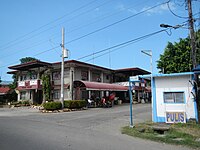 Municipal hall and police station
 -

-

-
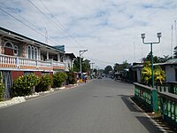 Town center
 -
 Parish of the Immaculate Conception


References
-
^ Forbes, W. Cameron (31 July 1909).
"Executive Order No. 57": 148–149. Retrieved 11 January 2023.
{{
cite journal}}
: Cite journal requires|journal=( help) - ^ Municipality of Palauig | (DILG)
- ^ "2015 Census of Population, Report No. 3 – Population, Land Area, and Population Density" (PDF). Philippine Statistics Authority. Quezon City, Philippines. August 2016. ISSN 0117-1453. Archived (PDF) from the original on May 25, 2021. Retrieved July 16, 2021.
- ^ a b c Census of Population (2020). "Region III (Central Luzon)". Total Population by Province, City, Municipality and Barangay. Philippine Statistics Authority. Retrieved 8 July 2021.
- ^ "PSA Releases the 2018 Municipal and City Level Poverty Estimates". Philippine Statistics Authority. 15 December 2021. Retrieved 22 January 2022.
- ^ "Province: Zambales". PSGC Interactive. Quezon City, Philippines: Philippine Statistics Authority. Retrieved 12 November 2016.
- ^ "Palauig: Average Temperatures and Rainfall". Meteoblue. Retrieved 26 April 2020.
- ^ Census of Population (2015). "Region III (Central Luzon)". Total Population by Province, City, Municipality and Barangay. Philippine Statistics Authority. Retrieved 20 June 2016.
- ^ Census of Population and Housing (2010). "Region III (Central Luzon)" (PDF). Total Population by Province, City, Municipality and Barangay. National Statistics Office. Retrieved 29 June 2016.
-
^ Censuses of Population (1903–2007).
"Region III (Central Luzon)".
Table 1. Population Enumerated in Various Censuses by Province/Highly Urbanized City: 1903 to 2007.
National Statistics Office.
{{
cite encyclopedia}}
: CS1 maint: numeric names: authors list ( link) - ^ "Province of Zambales". Municipality Population Data. Local Water Utilities Administration Research Division. Retrieved 17 December 2016.
- ^ "Poverty incidence (PI):". Philippine Statistics Authority. Retrieved December 28, 2020.
- ^ "Estimation of Local Poverty in the Philippines" (PDF). Philippine Statistics Authority. 29 November 2005.
- ^ "2003 City and Municipal Level Poverty Estimates" (PDF). Philippine Statistics Authority. 23 March 2009.
- ^ "City and Municipal Level Poverty Estimates; 2006 and 2009" (PDF). Philippine Statistics Authority. 3 August 2012.
- ^ "2012 Municipal and City Level Poverty Estimates" (PDF). Philippine Statistics Authority. 31 May 2016.
- ^ "Municipal and City Level Small Area Poverty Estimates; 2009, 2012 and 2015". Philippine Statistics Authority. 10 July 2019.
- ^ "PSA Releases the 2018 Municipal and City Level Poverty Estimates". Philippine Statistics Authority. 15 December 2021. Retrieved 22 January 2022.
External links
Places adjacent to Palauig | |
|---|---|
| Municipalities | |
|---|---|
| Highly urbanized city |
|
| Barangays | |