| Paddys River Australian Capital Territory | |
|---|---|
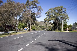
 Looking south-east, towards the
Murrumbidgee River, on North Street in Tharwa. | |
|
| |
| Coordinates | 35°30′49″S 149°04′10″E / 35.51361°S 149.06944°E |
| Gazetted | 12 May 1966 [1] |
| Territory electorate(s) | Brindabella |
| Federal division(s) | Bean |
Paddys River is a district in the Australian Capital Territory in Australia. [2] [3]
Localities
References
- ^ "Districts Ordinance 1966 No. 5 (ACT)" (PDF).
- ^ Australian Capital Territory Districts Act 1966 (repealed), last accessed 16 November 2014
- ^ "ACT Legislative Assembly - Electoral Boundaries Redistribution Boundaries to remain unchanged". ACT electoral commission offices of the act legislative assembly. 12 September 2003. Retrieved 26 January 2019.
