| Padas River | |
|---|---|
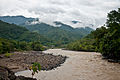
 View of the river. | |
| Native name | Sungai Padas ( Malay) in Long Pasia. |
| Location | |
| Country | |
| State | |
| Division | Interior Division |
| Precise location | Northwestern Borneo |
| Physical characteristics | |
| Source | |
| • location | From Long Pasia through mountains in Beaufort, Keningau and Tenom Districts |
| Mouth | |
• location | At Beaufort District into South China Sea |
• coordinates | 5°10′50.4″N 115°33′36.7″E / 5.180667°N 115.560194°E |
• elevation | Sea level |
| Length | 120 km (75 mi) [1] |
| Basin size | 9,180 km2 (3,544 sq mi) [2] |
| Basin features | |
| River system | Crocker Range [3] [4] |
The Padas River ( Malay: Sungai Padas) is a river in Interior Division, southwestern Sabah of Malaysia. It has a total length of 120 km (75 mi) from its headwaters in the mountains of northwest Sabah to its outlet at the South China Sea, southwest of Beaufort town. It originates from the Long Pasia in Sipitang and goes through the mountains in the interior Beaufort, Keningau and Tenom Districts, which are part of the Crocker Range system. [4] Padas river is from Long Pasia.
Features
The river is important to provide water supply to Labuan and both districts of Beaufort and Tenom including as the main source of hydroelectric power to entire west coast of Sabah. [3] The river is among the destination for water rafting activities in Sabah aside from Liwagu and Kiulu River. [5] [6]
-
 Rocks in the river.
 -
 The river view from Padas Valley.
 -
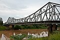 Vehicle bridge passing the river in Beaufort.
 -
 Water rafting activities in the river whitewater.


See also
Further reading
-
"Kompendium (Data dan Maklumat Asas JPS)" [Compendium (DID Basic Data and Information)] (PDF) (in Malay). Department of Irrigation and Drainage, Malaysia. 2018: 26. Archived from
the original (PDF) on 24 May 2019. Retrieved 16 July 2019.
{{
cite journal}}
: Cite journal requires|journal=( help)
References
- ^ "Japan Study on Power Demands in Sabah" (PDF). p. 12/107 [2-2]. Archived from the original (PDF) on 16 July 2019. Retrieved 16 July 2019 – via Japan International Cooperation Agency.
- ^ "National Register of River Basins [List of River Basin Management Units (RBMU) – Sabah]" (PDF). Department of Irrigation and Drainage, Malaysia. 2003. p. 34. Retrieved 16 July 2019.
- ^ a b "SBCP - Identification of Potential Protected Areas Ulu Padas - (Final Report) » Background on Biodiversity Significance" (PDF). p. 6/63. Archived from the original (PDF) on 9 April 2016. Retrieved 16 July 2019 – via Ministry of Culture, Environment and Tourism, Government of Sabah.
- ^
a
b
"Crocker Range [Data Zone MY020]".
BirdLife International. 2003. Retrieved 17 July 2019.
{{
cite journal}}
: Cite journal requires|journal=( help) - ^ "Padas Rafting". Sabah Education Department. Archived from the original on 17 July 2019. Retrieved 17 July 2019.
- ^ Hafiz Ithnin (3 April 2018). "'Jump! Jump!', 'Boom! Boom!' [METROTV]" (in Malay). Harian Metro. Retrieved 17 July 2019.
External links
-
 Media related to
Padas River at Wikimedia Commons
Media related to
Padas River at Wikimedia Commons
|
| This article related to a river in Malaysia is a stub. You can help Wikipedia by expanding it. |