-
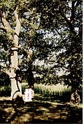 Four ancient oak trees ( c. 1500) near Păltiniș. Photo c. 1995.
This article needs additional citations for
verification. (February 2020) |
Păltiniș | |
|---|---|
 Coat of arms | |
 Location in Botoșani County | |
 Păltiniș Location in Romania | |
| Coordinates: 48°13′N 26°39′E / 48.217°N 26.650°E | |
| Country | Romania |
| County | Botoșani |
| Government | |
| • Mayor (2020–2024) | Costel Romanescu ( PNL) |
| Area | 75.07 km2 (28.98 sq mi) |
| Elevation | 240 m (790 ft) |
| Population (2021-12-01)
[1] | 4,145 |
| • Density | 55/km2 (140/sq mi) |
| Time zone | EET/ EEST (UTC+2/+3) |
| Postal code | 717295 |
| Vehicle reg. | BT |
| Website |
primariapaltinisbt |
Păltiniș is a commune in Botoșani County, Western Moldavia, Romania. It is composed of four villages: Cuzlău, Horodiștea, Păltiniș, and Slobozia.
The commune is located in the northern part of the county, on the border with Ukraine. Horodiștea village is situated at 48º15'N; this is the northernmost point in Romania.
Sights
A small cluster of century-old oak trees (dating approximately from the second half of the 15th century) is located in the neighboring forest of Teioasa, about 3 km (1.9 mi) northwest of Păltiniș.
The original cluster was composed of four oak trees. The trees formed a rectangle with its corners roughly pointing at the main cardinal points. Three of these oak trees were still standing as recently as 2005; the fourth was still standing in 1999, but was later removed; by then it had been severely damaged by disease. The trees are at least 30 metres (98 ft) tall.
The trees are locally known as "Stejarii lui Ștefan cel Mare" ( Stephen the Great's Oak Trees). They roughly mark the halfway point on the route between Suceava (Stephen's seat) and the Hotin Fortress ( Khotyn, near Kamyanets-Podilskyi, Ukraine). Hotin was the strongest fort on the northern border of medieval Moldavia. Local lore states Stephen the Great stopped over at least once at this forest location; on one particular occasion four acorns were planted "at the corners of Stephen's table", from which acorns the trees ensued. An undated water well can be found nearby.
Natives
- Doxachi Hurmuzachi (1782–1857), ethnic Romanian boyar from the Duchy of Bukovina
References


|
| This Botoșani County location article is a stub. You can help Wikipedia by expanding it. |