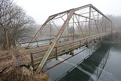
Otranto, Iowa | |
|---|---|
 The former
Otranto Bridge over the Cedar River | |
| Coordinates: 43°27′29″N 92°59′08″W / 43.45806°N 92.98556°W | |
| Country | United States |
| State | Iowa |
| County | Mitchell |
| Township | Otranto |
| Area | |
| • Total | 0.41 sq mi (1.06 km2) |
| • Land | 0.41 sq mi (1.06 km2) |
| • Water | 0.00 sq mi (0.00 km2) |
| Elevation | 1,171 ft (357 m) |
| Population | |
| • Total | 27 |
| • Density | 65.85/sq mi (25.42/km2) |
| Time zone | Central (CST) |
| ZIP code | 50472 (
St. Ansgar) |
| FIPS code | 19-60285 |
Otranto is an unincorporated community and census-designated place in Otranto Township, Mitchell County, in the U.S. state of Iowa. As of the 2020 census the population was 27, [2] unchanged from 2010.
Geography
The community is in northwestern Mitchell County, 7 miles (11 km) northwest of St. Ansgar, the post office serving Otranto, and 18 miles (29 km) northwest of Osage, the county seat. The Minnesota border is 3 miles (5 km) to the north.
Otranto is located along the Cedar River, approximately 4 miles (6 km) southwest of Mona.
Demographics
| Census | Pop. | Note | %± |
|---|---|---|---|
| 2010 | 27 | — | |
| 2020 | 27 | 0.0% | |
| U.S. Decennial Census [3] | |||
References
- ^ "2022 U.S. Gazetteer Files: Iowa". United States Census Bureau. Retrieved April 28, 2023.
- ^ a b "P1. Race – Otranto CDP, Iowa: 2020 DEC Redistricting Data (PL 94-171)". U.S. Census Bureau. Retrieved April 28, 2023.
- ^ "Census of Population and Housing". Census.gov. Retrieved June 4, 2016.


