| Monts Otish | |
|---|---|
 The Otish Mountains are the tall hills between
Lac Mistassini and
Manicouagan Reservoir, in the geographic centre of
Quebec
| |
| Highest point | |
| Peak | Mont Yapeitso |
| Elevation | 1,135 m (3,724 ft) |
| Coordinates | 52°19′20.28″N 70°26′42.36″W / 52.3223000°N 70.4451000°W |
| Geography | |
| Country | Canada |
| Province | Quebec |
The Monts Otish (Otish Mountains) are a range of tall hills in the geographic centre of Quebec, Canada, north of Lac Mistassini and Manicouagan Reservoir. Within the tall hills is the Réserve faunique des Lacs-Albanel-Mistassini-et-Waconichi.
-
 Otish Mountains from the upper Eastmain River
 -
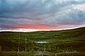 Sunset over burned forest plateau in Otish Mountains
 -
 Sunset over upper Eastmain River from Otish Mountains


|
| This Quebec-related article is a stub. You can help Wikipedia by expanding it. |