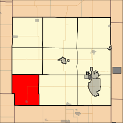
Osage Township | |
|---|---|
 Location in Crawford County | |
| Coordinates: 37°24′30″N 095°02′09″W / 37.40833°N 95.03583°W | |
| Country | United States |
| State | Kansas |
| County | Crawford |
| Area | |
| • Total | 54.58 sq mi (141.37 km2) |
| • Land | 54.35 sq mi (140.75 km2) |
| • Water | 0.24 sq mi (0.62 km2) 0.44% |
| Elevation | 919 ft (280 m) |
| Population (
2010) | |
| • Total | 686 |
| • Density | 13/sq mi (4.9/km2) |
| GNIS feature ID | 0469639 |
Osage Township is a township in Crawford County, Kansas, USA. As of the 2010 census, its population was 686. [1]
Geography
Osage Township covers an area of 54.58 square miles (141.4 km2) and contains one incorporated settlement, McCune. According to the USGS, it contains four cemeteries: Dumbald, Frog, Mc Cune and Mount Carmel.
References
External links
