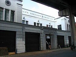
Oregon Portland Cement Building | |
Portland Historic Landmark
[1] | |
 Oregon Portland Cement Building in 2009 | |
| Location | 111 SE Madison Street Portland, Oregon, United States |
|---|---|
| Coordinates | 45°30′47″N 122°39′52″W / 45.513107°N 122.664476°W |
| Built | 1929 |
| Architect | Richard Sundeleaf, Alaska P & H |
| Architectural style | Late 19th And Early 20th Century American Movements, Classical Revival |
| MPS | Portland Eastside MPS |
| NRHP reference No. | 89000114 |
| Added to NRHP | March 8, 1989 |
The Oregon Portland Cement Building is a building in southeast Portland, Oregon, United States listed on the National Register of Historic Places. [2]
Further reading
- K. Zisman; J. Koler; J. Morrison; B. Grimala; A. Yost (August 15, 1988). "National Register of Historic Places Inventory/Nomination: Oregon Portland Cement Building" (pdf). National Park Service.
See also
References
- ^ Portland Historic Landmarks Commission (July 2014), Historic Landmarks -- Portland, Oregon (XLS), retrieved August 20, 2014.
- ^ "Oregon National Register List" (PDF). Oregon Parks and Recreation Department. October 19, 2009. p. 38. Retrieved June 8, 2011.
External links
-
 Media related to
Oregon Portland Cement Building at Wikimedia Commons


