Obando | |
|---|---|
| Municipality of Obando | |
 | |
 Flag  Seal | |
| Motto(s): Obando, Bayang Pinagpala! English: Obando, Blessed Town! | |
| Anthem: Bayang Pinagpala English: Blessed Town | |
 Map of Bulacan with Obando highlighted | |
.svg) Obando Location within the
Philippines | |
| Coordinates: 14°42′30″N 120°56′15″E / 14.7083°N 120.9375°E | |
| Country | Philippines |
| Region | Central Luzon |
| Province | Bulacan |
| District | 4th district |
| Founded | May 14, 1753 |
| Annexation to Polo | October 8, 1903 |
| Chartered | August 10, 1907 |
| Named for | Francisco José de Ovando, 1st Marquis of Brindisi |
| Barangays | 11 (see Barangays) |
| Government | |
| • Type | Sangguniang Bayan |
| • Mayor | Leonardo D. Valeda |
| • Vice Mayor | Arvin E. dela Cruz |
| • Representative | Linabelle Ruth R. Villarica |
| • Municipal Council | Members |
| • Electorate | 35,974 voters ( 2022) |
| Area | |
| • Total | 52.10 km2 (20.12 sq mi) |
| Elevation | 5.0 m (16.4 ft) |
| Population (2020 census)
[3] | |
| • Total | 59,978 |
| • Density | 1,200/km2 (3,000/sq mi) |
| • Households | 15,171 |
| Economy | |
| • Income class | 2nd municipal income class |
| • Poverty incidence | 4.66 |
| • Revenue | ₱ 202.6 million (2020) |
| • Assets | ₱ 233.3 million (2020) |
| • Expenditure | ₱ 188.7 million (2020) |
| • Liabilities | ₱ 81.86 million (2020) |
| Utilities | |
| • Electricity | Meralco |
| Time zone | UTC+8 ( PST) |
| ZIP code | 3021 |
| PSGC | |
| IDD : area code | +63 (0)44 |
| Native languages | Tagalog |
| Website |
obandopilipinas |
Obando, officially the Municipality of Obando ( Tagalog: Bayan ng Obando), is a 2nd class municipality in the province of Bulacan, Philippines. According to the 2020 census, it has a population of 59,978 people. [3]
It is 16 kilometers (9.9 mi) away from the Philippine capital Manila and is part of Manila's conurbation which reaches San Ildefonso in its northernmost part. [5]
History
Obando was likely originally called "Binuwangan" according to 18th century maps. In the 1734 map of the Philippine islands by Pedro Murillo Velarde, the places labeled "Vinuangan", "Polo" (currently Valenzuela), and "Maycauayan" were indicated separately and proximate to one another.

In the 18th century, the municipalities now known as Meycauayan, Valenzuela (formerly Polo) and Obando comprised only one town, the Municipality of Meycauayan. The towns of Polo and Obando formed a barrio called Catanghalan. In the year 1623, the municipality of Polo was organized which included the present-day territories of the Town of Obando. By virtue of a decree promulgated during the time of Governor and Captain General of the Archipelago, Francisco Jose de Obando y Solis, the town was created and separated from its mother town Polo on May 14, 1753. Upon the Governor's untimely death at the hands of the British during the Seven Years' War, the creation and establishment of the town was made and attended by the Alcalde Mayor of the province, Don Francisco Morales y Mozabe, the Provincial Minister, S. Gregorio, Rev. Fr. Alejandro Ferrer, together with numerous religious devotees. The minister who was chosen to administer the town was Rev. Fr. Manuel De Olivencia. On October 8, 1903, Obando merged with Polo by virtue of Act No. 932. [6]
In 1907, Obando was made an independent town of Bulacan. [7] Then through the untiring efforts of municipal officials, a portion of Gasak Navotas was reclaimed to form a part of Obando. The municipal officials, believing that this portion was once a part of the municipality but was adopted by Navotas in the course of time, effortlessly pushed through its claim to regain the area. The concerted action of all those concerned paid off when on January 30, 1975, by virtue of Presidential Decree No. 646, a portion of approximately 1.78 square kilometers of Gasak, Navotas was returned to Obando. This is mostly fishpond and sandy beach and expected that when fully developed, it would serve as a tourist attraction. By resolution of 1975 Municipal Council, the area was made into a barangay and named Nuestra Señora de Salambao in honor of one of its patron saints. [5]
Geography
Obando is bordered by Valenzuela to the east, Navotas and Malabon to the south, Bulakan to the north, and the waters of Manila Bay to the west.
Flat and low-lying coastal plains characterize the general topography of Obando. The area was formerly an estuary, but it filled up partially from the peripheral parts of sand bars and sand spits and formed up into the current area that mainly consists of a commercial district, partly industrial district, residential area and fishpond. Within the municipality are two rivers and three creeks, namely the Meycauayan River in the north, the Pinagkabalian River in the south, and Paco Creek, Hulo Creek and Pag-asa Creek traversing the town parallel to the provincial road. [5]
Obando, just like the other towns of Bulacan, has two pronounced seasons: dry and wet. The wet season is from May to October and the dry season is from November to April. The rainfall of the wet season accounts for about 80% of the annual rainfall, which is due to monsoons and typhoons. [5]
Barangays
Obando is politically subdivided into 11 barangays. Each barangay consists of 7 puroks and some have sitios. There are 8 urban and 3 rural barangays.
Barangays Binuangan (ancient "Binwangan" mentioned on the Laguna Copperplate Inscription, which is the oldest written document of Philippines inscribed in Indianized script, dating back to 900 CE) and Salambao are located along the Paliwas River, and can be reached only by means of motorized boats. [5]
| PSGC | Barangay | Population | ±% p.a. | |||
|---|---|---|---|---|---|---|
| 2020 [3] | 2010 [8] | |||||
| 031414001 | Binuangan | 8.7% | 5,218 | 5,213 | 0.01% | |
| 031414002 | Catanghalan | 5.3% | 3,164 | 3,181 | −0.05% | |
| 031414003 | Hulo | 4.2% | 2,503 | 2,475 | 0.11% | |
| 031414004 | Lawa | 19.1% | 11,452 | 8,118 | 3.50% | |
| 031414005 | Salambao | 2.6% | 1,575 | 1,336 | 1.66% | |
| 031414006 | Paco | 11.4% | 6,866 | 6,676 | 0.28% | |
| 031414007 | Pag‑asa ( Poblacion) | 5.8% | 3,458 | 3,381 | 0.23% | |
| 031414008 | Paliwas | 10.2% | 6,113 | 6,081 | 0.05% | |
| 031414009 | Panghulo | 21.3% | 12,763 | 12,533 | 0.18% | |
| 031414010 | San Pascual | 12.1% | 7,228 | 7,074 | 0.22% | |
| 031414011 | Tawiran | 3.1% | 1,857 | 1,941 | −0.44% | |
| Total | 59,978 | 58,009 | 0.33% | |||
Climate
| Climate data for Obando, Bulacan | |||||||||||||
|---|---|---|---|---|---|---|---|---|---|---|---|---|---|
| Month | Jan | Feb | Mar | Apr | May | Jun | Jul | Aug | Sep | Oct | Nov | Dec | Year |
| Mean daily maximum °C (°F) | 29 (84) |
30 (86) |
32 (90) |
34 (93) |
33 (91) |
31 (88) |
30 (86) |
29 (84) |
29 (84) |
30 (86) |
30 (86) |
29 (84) |
31 (87) |
| Mean daily minimum °C (°F) | 20 (68) |
20 (68) |
21 (70) |
23 (73) |
24 (75) |
25 (77) |
24 (75) |
24 (75) |
24 (75) |
23 (73) |
22 (72) |
21 (70) |
23 (73) |
| Average precipitation mm (inches) | 7 (0.3) |
7 (0.3) |
9 (0.4) |
21 (0.8) |
101 (4.0) |
152 (6.0) |
188 (7.4) |
170 (6.7) |
159 (6.3) |
115 (4.5) |
47 (1.9) |
29 (1.1) |
1,005 (39.7) |
| Average rainy days | 3.3 | 3.5 | 11.1 | 8.1 | 18.9 | 23.5 | 26.4 | 25.5 | 24.5 | 19.6 | 10.4 | 6.4 | 181.2 |
| Source: Meteoblue [9] | |||||||||||||
Demographics
| Year | Pop. | ±% p.a. |
|---|---|---|
| 1903 | 8,051 | — |
| 1918 | 7,604 | −0.38% |
| 1939 | 10,026 | +1.33% |
| 1948 | 11,957 | +1.98% |
| 1960 | 18,733 | +3.81% |
| 1970 | 27,176 | +3.79% |
| 1975 | 32,378 | +3.57% |
| 1980 | 39,618 | +4.12% |
| 1990 | 46,346 | +1.58% |
| 1995 | 51,488 | +1.99% |
| 2000 | 52,906 | +0.58% |
| 2007 | 56,258 | +0.85% |
| 2010 | 58,009 | +1.12% |
| 2015 | 59,197 | +0.39% |
| 2020 | 59,978 | +0.26% |
| Source: Philippine Statistics Authority [10] [8] [11] [12] | ||
In the 2020 census, the population of Obando, Bulacan, was 59,978 people, with a density of 1,200 inhabitants per square kilometer or 3,100 inhabitants per square mile. [3]
In 2002, Obando had an estimated population of 58,245 wherein 49% were male and 51% were female. Of the current population, about 14% live in rural barangays while the rest constitute the urban population. There are 12,349 households. The average monthly income of a household is ₱9,000.00, slightly below the ₱9,540.00 minimum for a family of 6 threshold set by Department of Social Welfare and Development. [5]
Economy
Graphs are unavailable due to technical issues. There is more info on
Phabricator and on
MediaWiki.org. |
Radio
.jpg)
Obando is also the transmitter site of some AM stations, primarily broadcasting the Mega Manila area. Among them are:
- Super Radyo DZBB 594 ( GMA Network)
- DZMM Radyo Patrol 630 ( ABS-CBN Corporation, defunct)
- DWIZ 882 ( Aliw Broadcasting Corporation)
- DWPM Radyo 630 ( Philippine Collective Media Corporation)
- DZIQ Radyo Inquirer 990 ( Trans-Radio Broadcasting Corporation, defunct)
- DZEC Radyo Agila 1062 ( Eagle Broadcasting Corporation)
- INC Radio DZEM 954 ( Christian Era Broadcasting Service International)
- DZME 1530 ( Capitol Broadcasting Center)
Government
Elected officials
List of mayors
- Antonio Joaquin (OIC 1986 - 1989)
- Bienvenido Evangelista (1989–1992)
- Conrado Lumabas Jr. (1992–2001)
- Onesimo Joaquin (2001–2004)
- Zoilito Santiago (2004–2007)
- Orencio Gabriel (2007–2013)
- Edwin C. Santos (2013–2022)
- Leonardo Valeda (2022–Present)
List of vice mayors
Vice Mayors of Obando:
- Remigio Dela Cruz (1988–1992)
- Gaudioso Espinosa (1992–1995)
- Romerico Roque Santos (1995–1998)
- Onesimo Joaquin (1998–2001)
- Zoilito Santiago (2001–2004)
- Jose Correa (2004–2007)
- Leonardo Pantanilla (2007–2010)
- Danilo de Ocampo (2010–2013)
- Zoilito Santiago (2013–2016)
- Arvin Dela Cruz (2016–Present)
Gallery
-
 Old Municipal hall
 -
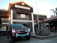
 New Municipal Hall
 -
 Bantayog ng Kagitingan (Federasyon ng mga Beterano ng Obando District IV, October 12, 1996; English: Shrine of Valour)
 -

-
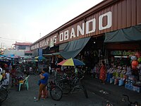 Obando Public Market
 -
 Municipal Fishport
 -
 Colegio de San Pascual Baylon
 -
 Obando School of Fisheries
 -
 Bulacan Polytechnic College - Obando Campus
 -
 Paco Catholic Cemetery
 -
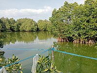 Mangroves beside Paliwas Road
 -
 A fish pen in Obando


See also
References
- ^ Municipality of Obando | (DILG)
- ^ "2015 Census of Population, Report No. 3 – Population, Land Area, and Population Density" (PDF). Philippine Statistics Authority. Quezon City, Philippines. August 2016. ISSN 0117-1453. Archived (PDF) from the original on May 25, 2021. Retrieved July 16, 2021.
- ^ a b c d Census of Population (2020). "Region III (Central Luzon)". Total Population by Province, City, Municipality and Barangay. Philippine Statistics Authority. Retrieved July 8, 2021.
- ^ "PSA Releases the 2018 Municipal and City Level Poverty Estimates". Philippine Statistics Authority. December 15, 2021. Retrieved January 22, 2022.
- ^ a b c d e f Obando, Bayang Pinagpala! (Obando, Blessed Town!), Pamahalaang Bayan ng Obando (Local Government of Obando), 2006/2007
- ^ Act No. 932 (October 8, 1903), "An Act Reducing the Twenty-five Municipalities of the Province of Bulacan to Thirteen", Senate of the Philippines Legislative Digital Resources, retrieved July 3, 2023
- ^ Act No. 1588 (October 8, 1903), "An Act Increasing the Number of Municipalities in the Province of Bulacan From Thirteen to Fourteen, by Separating From Polo the Former Municipality of Obando and Giving the Latter the Territory Which It Comprised Prior to the Passage of Act Numbered Nine Hundred and Thirty-two.", Senate of the Philippines Legislative Digital Resources, retrieved July 3, 2023
- ^ a b Census of Population and Housing (2010). "Region III (Central Luzon)" (PDF). Total Population by Province, City, Municipality and Barangay. National Statistics Office. Retrieved June 29, 2016.
- ^ "Obando: Average Temperatures and Rainfall". Meteoblue. Retrieved May 12, 2020.
- ^ Census of Population (2015). "Region III (Central Luzon)". Total Population by Province, City, Municipality and Barangay. Philippine Statistics Authority. Retrieved June 20, 2016.
-
^ Censuses of Population (1903–2007).
"Region III (Central Luzon)".
Table 1. Population Enumerated in Various Censuses by Province/Highly Urbanized City: 1903 to 2007.
National Statistics Office.
{{
cite encyclopedia}}
: CS1 maint: numeric names: authors list ( link) - ^ "Province of". Municipality Population Data. Local Water Utilities Administration Research Division. Retrieved December 17, 2016.
- ^ "Poverty incidence (PI):". Philippine Statistics Authority. Retrieved December 28, 2020.
- ^ "Estimation of Local Poverty in the Philippines" (PDF). Philippine Statistics Authority. November 29, 2005.
- ^ "2003 City and Municipal Level Poverty Estimates" (PDF). Philippine Statistics Authority. March 23, 2009.
- ^ "City and Municipal Level Poverty Estimates; 2006 and 2009" (PDF). Philippine Statistics Authority. August 3, 2012.
- ^ "2012 Municipal and City Level Poverty Estimates" (PDF). Philippine Statistics Authority. May 31, 2016.
- ^ "Municipal and City Level Small Area Poverty Estimates; 2009, 2012 and 2015". Philippine Statistics Authority. July 10, 2019.
- ^ "PSA Releases the 2018 Municipal and City Level Poverty Estimates". Philippine Statistics Authority. December 15, 2021. Retrieved January 22, 2022.
External links
Places adjacent to Obando, Bulacan | ||||||||||||||||
|---|---|---|---|---|---|---|---|---|---|---|---|---|---|---|---|---|
| ||||||||||||||||
| Municipalities | |
|---|---|
| Component cities | |