This article needs additional citations for
verification. (December 2009) |
 | |
|---|---|
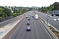
 The motorway west of
Waterview | |
| Route information | |
| Maintained by NZ Transport Agency | |
| Length | 21 km (13 mi) |
| Existed | 1952–present |
| Component highways | State Highway 16 |
| Major junctions | |
| East end | |
| West end | Brigham Creek Road, Whenuapai |
| Location | |
| Country | New Zealand |
| Primary destinations | Central Auckland, West Auckland |
| Highway system | |
The Northwestern Motorway (also known historically as the Auckland–Kumeu Motorway), part of State Highway 16 (SH 16), is the major western route and secondary northern route out of Auckland in New Zealand. Twenty-one kilometres in length, the motorway runs from Stanley St in Parnell through the Central Motorway Junction, and west through Central Auckland and West Auckland before continuing northwest and terminating outside of Kumeū. Its western terminus is at Brigham Creek Road in Whenuapai. A large part of it forms the middle section of the Western Ring Route.
History
The first section of the Northwestern Motorway, from Waterview to Te Atatū Peninsula, was finished in 1952. [1] [2] The section between Waterview and Rosebank peninsula is known as "The Causeway". [3] The next section opened for traffic in 1955, then offering a two-laned 7.8 km section from Great North Road (current Exit 8) to Lincoln Road (current Exit 16). The section involved bridges over inlets of the Waitematā Harbour, which cut the journey between central Auckland and its airport at Whenuapai by 8 km. This section was later upgraded to four lanes.
In 1957, the motorway was extended westwards by one km to Lincoln Park Avenue, between the current Lincoln Road and Royal Road interchanges. In 1961, it was extended again by 2.7 km to Hobsonville Road at what is now Westgate. Traffic could now travel 11.5 km on the Northwestern Motorway, and the journey between Auckland and Whenuapai was cut by a total of 9 km compared with local roads.
In 1966, the current Auckland International Airport opened at Mangere, and Whenuapai reverted to a military airport. This affected the use of the motorway, delaying further extensions.
Motorway construction recommenced in the late 1970s, to connect the Northwestern Motorway at Waterview to the Auckland city centre, bypassing Great North Road. The first section to open was in 1979, stretching 2.4 km from Newton Road (Exit 5) to Western Springs, at the current site of the eastbound on/off-ramps for St Lukes Road (Exit 6). At the same time, ramps opened as part of the Central Motorway Junction from Newton Road to Nelson Street and Hobson Street (now Exit 4B), connecting the Northwestern Motorway to the city centre. Traffic could access the Southern and Northern Motorways indirectly from the Nelson Street and Hobson Street intersections.
In 1981, the 2.4 km section between Great North Road at Waterview and Motions Road near Western Springs opened, leaving a small 1 km gap where traffic had to use Great North Road. This gap was filled in 1983 when the St Lukes Road interchange was completed.
In 1988, ramps were installed at the Central Motorway Junction to allow direct access between the Southern Motorway and the Northwestern Motorway. The following year, ramps opened between Grafton Gully and the Northwestern Motorway, allowing motorway traffic direct access to the eastern city centre and the port.
In 2006, two new ramps were installed to directly connect the Northwestern Motorway and the Northern Motorway. [4]
On 7 August 2011 a 3 kilometre, 4-lane extension of the Northwestern Motorway opened from Hobsonville Road to Brigham Creek Road in Whenuapai, along with a 6 kilometre, 4-lane extension of State Highway 18 motorway from the end of the Northwestern Motorway at Hobsonville Road to the western end of Upper Harbour Bridge in Hobsonville.
From 2012 to 2016 extra lanes were added between St Lukes and Westgate in preparation for the opening, on 2 July 2017, of the Waterview Connection.
-
 Looking west along the Northwestern Motorway between Newton Road and Bond Street.
 -
 Looking east towards the Central Motorway Junction.


Interchanges
| Location | km | mi | Exit | Destinations | Notes | |
|---|---|---|---|---|---|---|
| Parnell | 1.2 | 0.75 | Northwestern Motorway begins | |||
| Grafton | 1.7 | 1.1 | 2 | Westbound exit and eastbound entrance | ||
| 1.8 | 1.1 | 2A | Wellesley Street | Eastbound exit and westbound entrance | ||
| Auckland CBD | 2.8 | 1.7 | 3 | Westbound exit and eastbound entrance | ||
| 3.2 | 2.0 | 4C | Eastbound exit and westbound entrance | |||
| 3.3 | 2.1 | 4A | Eastbound exit and westbound entrance | |||
| Grey Lynn | 3.5 | 2.2 | 5 | Newton Road | Eastbound exit and westbound entrance | |
| Western Springs | 6.3 | 3.9 | 6 | Route 9 (St Lukes Road) – Zoo, MOTAT | ||
| Point Chevalier | 8.0 | 5.0 | 8A | Route 11 (Great North Road) | ||
| 8.1 | 5.0 | 8B | Waterview Connection | |||
| Avondale North | 10.8 | 6.7 | 11 | Rosebank Road | Westbound exit and eastbound entrance | |
| 12.3 | 7.6 | 12 | Patiki Road | Eastbound exit and westbound entrance | ||
| Te Atatū South | 13.5 | 8.4 | 14 | Route 13 (Te Atatu Road) | ||
| Lincoln North | 15.6 | 9.7 | 16 | Route 19 (Lincoln Road) | ||
| Massey East | 17.8 | 11.1 | 18 | Royal Road | Westbound exit and eastbound entrance | |
| Westgate | 19.4 | 12.1 | 19 | Westbound exit and eastbound entrance | ||
| Whenuapai | 22.9 | 14.2 | Roundabout; Northwestern Motorway ends | |||
| 1.000 mi = 1.609 km; 1.000 km = 0.621 mi | ||||||
See also
References
- ^ About the City – The History Archived 14 May 2010 at the Wayback Machine (from the Waitakere City Council website. Accessed 1 December 2009.)
- ^ Greater Auckland webpage "The Birth of the North-Western Motorway" accessed on 19-Jun-2018
- ^ NZ Transport Agency webpage "SH16 Causeway Upgrade" accessed on 19-Jun-2018
- ^ Auckland Motorways – New Zealand Transport Agency Archived 12 June 2009 at the Wayback Machine