This article relies largely or entirely on a
single source. (April 2023) |

The North Face is the northern side of Mount Everest. [1] George Mallory's body was found on the North face. [1] The North Face is a place where one author/climber noted, "a simple slip would mean death." [1]
Views
 |
 |
 |
Routes

Green line
|
Standard route from north, mainly identical with Mallory's route in 1924; high camps on c.7700 m and 8300 m (indicated by two triangles), present day camp on 8300 m is located a bit further west (for general reference, the route's topographic map and elevation profile can be found here). |
Navy blue line
|
Zakharov Couloir. |
Light blue line
|
Messner's traverse from north ridge to Norton Couloir in 1980 ("Everest Solo by Fair Means") w/o O2. |
Red line
|
Great Couloir or Norton Couloir. |
Purple line
|
Complete northeast ridge with Three Pinnacles; Japanese route to the top. Climbed before by Russell Brice & Comp., but only the purple-marked part of the ridge, without going to the summit; descent via standard route. |
Yellow line and Dark blue line
|
American 1963, "The West Ridge". |
Orange line
|
Yugoslavian route, 1979. |
Dark blue line
|
Hornbein Couloir. |
| †1 | Resting place of Mallory's body, discovered in 1999 (graveyard with more than 15 bodies, according to Conrad Anker). |
| †2 | 1st Step, resting place of Francys Arsentiev, " Green Boots", David Sharp. |
| †3 | 2nd Pinnacle, resting place of Peter Boardman (+1982) in 1992. |
| ? | 2nd step, base at 8605 m, c.30 m high, (difficulty: 5–9/10). |
| (a) | Point at ca. 8321 m, reached by George Ingle Finch with supplementary oxygen in 1922. |
| (b) | Point at 8572.8 m on the western side of the Couloir, reached by Edward Felix Norton 1924 without supplementary oxygen (Norton preferred climbing the wall rather than climbing the ridge). |
| (c) | Area left out by the Yugoslavian party on their "complete West Ridge" ascent in 1979. |
| (d) | Difficult area that forced Americans, Tom Hornbein and Willi Unsoeld, to traverse from the west ridge to the north face in 1963. |
| Changtse is in the foreground |
Location
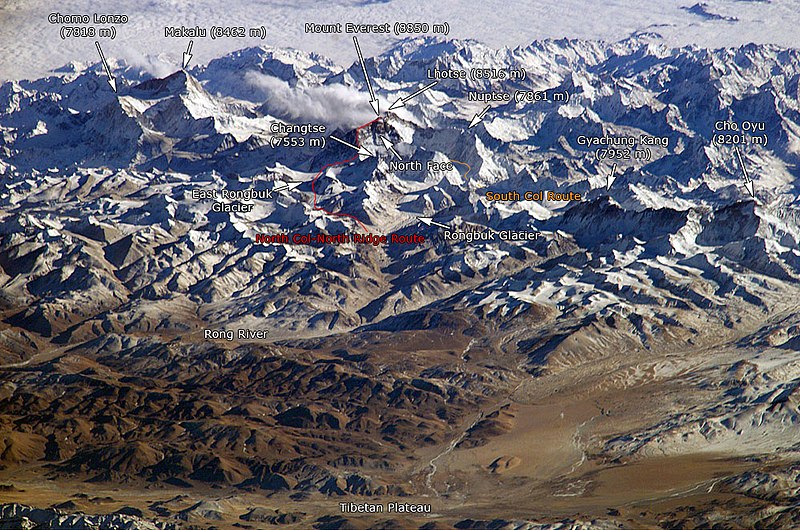
Southern and northern climbing routes as seen from the
International Space Station. (The names on the photo are links to corresponding pages.)
Above
.jpg)
See also
- Kangshung face (East side)
References
External links
Wikimedia Commons has media related to
Everest North Face.
