Nisshin
日進市 | |
|---|---|
 | |
 Flag  Seal | |
 Location of Nisshin in Aichi Prefecture | |
 Nisshin | |
| Coordinates: 35°07′55.1″N 137°02′22″E / 35.131972°N 137.03944°E | |
| Country | Japan |
| Region | Chūbu ( Tōkai) |
| Prefecture | Aichi |
| Government | |
| • Mayor | Kozo Hagino (since July 2007) |
| Area | |
| • Total | 34.91 km2 (13.48 sq mi) |
| Population (October 1, 2019) | |
| • Total | 91,795 |
| • Density | 2,600/km2 (6,800/sq mi) |
| Time zone | UTC+9 ( Japan Standard Time) |
| – Tree | Osmanthus |
| – Flower | Hydrangea |
| Phone number | 0561-73-2111 |
| Address | 268 Kanikochō Ikeshita, Nisshin-shi, Aichi-ken 470-0192 |
| Website | Official website |
Nisshin (日進市, Nisshin-shi) is a city in Aichi Prefecture, Japan. As of 1 October 2019 [update], the city had an estimated population of 91,795 in 37,398 households, [1] and a population density of 2,629 persons per km². The total area of the city was 34.91 square kilometres (13.48 sq mi).
Geography

Nisshin is located on the flatlands of central Aichi Prefecture, and is bordered by the metropolis of Nagoya to the west.
Climate
The city has a climate characterized by hot and humid summers and relatively mild winters ( Köppen climate classification Cfa). The average annual temperature in Nisshin is 15.7 °C. The average annual rainfall is 1603 mm with September as the wettest month. The temperatures are highest on average in August, at around 28.0 °C, and lowest in January, at around 4.1 °C. [2]
Demographics
Per Japanese census data, [3] the population of Nisshin has grown rapidly over the past 50 years.
| Year | Pop. | ±% |
|---|---|---|
| 1940 | 8,055 | — |
| 1950 | 10,880 | +35.1% |
| 1960 | 11,187 | +2.8% |
| 1970 | 21,486 | +92.1% |
| 1980 | 41,024 | +90.9% |
| 1990 | 50,335 | +22.7% |
| 2000 | 70,188 | +39.4% |
| 2010 | 84,187 | +19.9% |
Neighboring municipalities
History
Late modern period
With the establishment of the modern municipalities system on October 1, 1889, the villages of Iwasaki, Shiroyama and Kaguyama were created within Aichi District of Aichi Prefecture. These three villages merged on May 10, 1906, to create the village of Nisshin. The village was named after the Imperial Japanese Navy cruiser Nisshin, which became famous during the Russo-Japanese War.
Contemporary history
Nisshin became a town on January 1, 1951, and was elevated to city status on October 1, 1994.
Government

Nisshin has a mayor-council form of government with a directly elected mayor and a unicameral city legislature of 20 members. The city contributes two members to the Aichi Prefectural Assembly. In terms of national politics, the city is part of Aichi District 7 of the lower house of the Diet of Japan.
External relations
Twin towns – Sister cities
International
- Sister city
National
-
 Kiso (
Nagano Prefecture,
Chūbu region)
Kiso (
Nagano Prefecture,
Chūbu region)
- since April 12, 1992
-
 Shima (
Mie Prefecture,
Kansai region)
Shima (
Mie Prefecture,
Kansai region)
- since September 26, 2014
Education

University
- Aichi Gakuin University – Nisshin campus
- Aichi Toho University – Nisshin ground
- Nagoya University of Arts and Sciences
- Nagoya University of Commerce & Business
- Nagoya University of Foreign Studies
- Sugiyama Jogakuen University – Nisshin campus
- Meijo University – Nisshin campus (Nisshin ground)
Primary and secondary education
- Nisshin has nine public elementary schools and four public middle schools operated by the city government and two public high schools operated by the Aichi Prefectural Board of Education. There is also one private high school.
Transportation
Railways
Conventional lines
- Meitetsu Toyota Line: - Komenoki – Nisshin – Akaike –
Subways
Roads

Expressways
 Tōmei Expressway
- - Togo Parking Area –
-
 Nagoya-Seto Expressway
Japan National Route
-

-

-

-
 Nissin Junction


Local attractions
Tourist attractions
- Historic sites
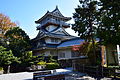
- Ruins of Iwasaki Castle [5]
- Myousen-ji temple]
- Hakusan-gu shrine
- Old Ichikawa House
-
-
 Myousen-ji
 -
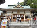 Hakusan-gu
 -
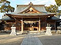 Tenchi Shrine
 -
 Old Ichikawa House


.JPG)
.jpg)
- Parks
- Aichi Pond
- Aichi Ranch
- Goshikien
Museums
-
 Aichi Pond
 -
 Goshikien
 -

-


.JPG)

Notable people from Nisshin
- Michiko Hattori, professional golfer
- Akira Ishida, voice actor
- Gorō Taniguchi, anime director, writer
- Ayaka Suwa, voice actress
External links
- Official website (in Japanese)
References
- ^ Nisshin City official statistics (in Japanese)
- ^ Nisshin climate data
- ^ Nisshin population statistics
- ^ "Online directory: Kentucky, USA". Sister Cities International. Archived from the original on October 2, 2006. Retrieved June 11, 2007.
- ^ 岩崎城 (Iwasaki Castle)
- ^ マスプロ美術館 (Maspro Art Museum)
| International | |
|---|---|
| National | |
| Geographic | |
| Nagoya |
| |||
|---|---|---|---|---|
| Core cities | ||||
| Special city | ||||
| Cities | ||||
| Districts | ||||
| Former Districts | ||||