Neu-Ulm | |
|---|---|
 Flag  Coat of arms | |
|
| |
| Country | Germany |
| State | Bavaria |
| Adm. region | Swabia |
| Capital | Neu-Ulm |
| Government | |
| • District admin. | Thorsten Freudenberger ( CSU) |
| Area | |
| • Total | 515 km2 (199 sq mi) |
| Population (31 December 2022)
[1] | |
| • Total | 180,425 |
| • Density | 350/km2 (910/sq mi) |
| Time zone | UTC+01:00 ( CET) |
| • Summer ( DST) | UTC+02:00 ( CEST) |
| Vehicle registration | ILL, NU |
| Website | landkreis.neu-ulm.de |
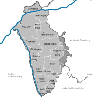
Neu-Ulm is a Landkreis (district) in Swabia, Bavaria, Germany. It is bounded by (from the east and clockwise) the districts of Günzburg and Unterallgäu and the state of Baden-Württemberg (districts Biberach and Alb-Donau, city of Ulm).
The district was established in 1972 by merging the former districts of Neu-Ulm and Illertissen with the previously district-free city of Neu-Ulm.
The district includes the eastern metropolitan area of the city of Ulm. The Danube and its tributary, the Iller, form the western border of the district.
Coat of arms
The coat of arms displays:
- the moor from the arms of Kirchberg
- the horn from the arms of Neuffen
Towns and municipalities
| Towns | Municipalities | |
|---|---|---|
References
- ^ Genesis Online-Datenbank des Bayerischen Landesamtes für Statistik Tabelle 12411-003r Fortschreibung des Bevölkerungsstandes: Gemeinden, Stichtag (Einwohnerzahlen auf Grundlage des Zensus 2011) ( Hilfe dazu).
External links
Wikimedia Commons has media related to
Landkreis Neu-Ulm.
- Official website (German)
Towns and municipalities in
Neu-Ulm (district) | ||
|---|---|---|
48°20′N 10°10′E / 48.333°N 10.167°E
| International | |
|---|---|
| National | |
|
| This Neu-Ulm district location article is a stub. You can help Wikipedia by expanding it. |