| Nescopeck State Park | |
|---|---|
 An abandoned silo at Nescopeck State Park | |
 Location of Nescopeck State Park in Pennsylvania  Nescopeck State Park (the United States) | |
| Location | Luzerne, Pennsylvania, United States |
| Coordinates | 41°04′35″N 75°54′10″W / 41.07639°N 75.90278°W |
| Area | 3,550 acres (14.4 km2) |
| Elevation | 1,053 ft (321 m) [1] |
| Established | April 2005 |
| Governing body | Pennsylvania Department of Conservation and Natural Resources |
| Website | Nescopeck State Park |
Nescopeck State Park is a Pennsylvania state park on 3,550 acres (1,437 ha) in Butler and Dennison Townships, Luzerne County, Pennsylvania (in the United States). The park is one of the newest state parks in Pennsylvania. In the early 1970s, the state acquired 164 properties which made up the park. The park's Environmental Education Center is one of its newest additions; it opened in April 2005. Nescopeck Creek runs through the valley between Mount Yeager and Nescopeck Mountain. The park is near Interstate 80 just off Pennsylvania Route 309 (near Conyngham).
Trails
There are 19 miles (31 km) of trails in Nescopeck State Park. The trails go through forests, meadows and wetlands. Most trails begin at Honey Hole Road which is the main access road for the park. The trails are open for cross-country skiing but closed to mountain biking. [2]
Wildlife
200 acres (81 ha) of wetlands, forests, and the banks of Nescopeck Creek are the habitat of:
- over 160 different species of birds
- 30 species of reptiles and amphibians
- over 600 species of plants. [2]
Hunting and fishing
Hunting is permitted on most of Nescopeck State Park. Hunters are expected to follow the rules and regulations of the Pennsylvania Game Commission. The common game species are squirrels, turkey, woodcock, and white-tailed deer. Hunters may also access State Game Lands 187 through the park for additional hunting opportunities. [2]
Lake Frances is a 9 acres (3.6 ha) man-made lake on a tributary of Nescopeck Creek. The lake has panfish, bass and trout in its waters. Nescopeck Creek is designated as a high quality cold-water fishery with brown and brook trout. [2]
Gallery
-
 A mountain in the park
 -
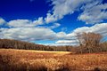 Lightly wooded meadow
 -
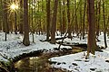
 Hemlocks near Nescopeck Creek
 -
 Snow-covered mountains in Nescopeck State Park
 -
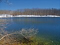 Lake Frances in Nescopeck State Park
 -
 Nescopeck State Park

.jpg)
.jpg)
.jpg)

_(8585827903).jpg)
Nearby state parks
The following state parks are within 30 miles (48 km) of Nescopeck State Park: [3] [4] [5]
- Beltzville State Park ( Carbon County)
- Big Pocono State Park ( Monroe County)
- Frances Slocum State Park (Luzerne County)
- Gouldsboro State Park (Monroe and Wayne Counties)
- Hickory Run State Park (Carbon County)
- Lehigh Gorge State Park (Carbon and Luzerne Counties)
- Locust Lake State Park ( Schuylkill County)
- Ricketts Glen State Park ( Columbia, Luzerne, and Sullivan Counties)
- Tobyhanna State Park (Monroe and Wayne Counties)
- Tuscarora State Park (Schuylkill County)
References
- ^ "Nescopeck State Park". Geographic Names Information System. United States Geological Survey. September 5, 2007. Retrieved June 17, 2008.
- ^ a b c d "Nescopeck State Park". Pennsylvania Department of Conservation and Natural Resources. Archived from the original on September 27, 2011. Retrieved November 15, 2006.
- ^ "Find a Park by Region (interactive map)". Pennsylvania Department of Conservation and Natural Resources. Archived from the original on September 24, 2011. Retrieved November 18, 2011.
- ^ Michels, Chris (1997). "Latitude/Longitude Distance Calculation". Northern Arizona University. Retrieved April 23, 2008.
- ^ "2007 General Highway Map Luzerne County Pennsylvania" (PDF) (Map). 1:65,000. Pennsylvania Department of Transportation, Bureau of Planning and Research, Geographic Information Division. Archived from the original (PDF) on June 2, 2014. Retrieved July 27, 2007. Note: shows Nescopeck State Park