(Redirected from
Naxi District)
Naxi
纳溪区 | |
|---|---|
 | |
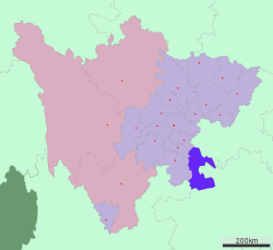
 Naxi District in Luzhou | |
 Luzhou in Sichuan | |
| Country | China |
| Province | Sichuan |
| Prefecture-level city | Luzhou |
| Area | |
| • Total | 1,150.6 km2 (444.2 sq mi) |
| Population (2018)
[1] | |
| • Total | 469,000 |
| • Density | 410/km2 (1,100/sq mi) |
| Time zone | UTC+8 ( China Standard) |
Naxi District (Tibetan: Jang; simplified Chinese: 纳溪区; traditional Chinese: 納溪區; pinyin: Nàxī Qū) is a county-level district of the city of Luzhou, Sichuan Province, China. Formerly a county of Luzhou, Naxi became a district of Luzhou in 1996.
History
Naxi, as a county, has a history of 764 years before it became a district of Luzhou in 1996. [1]
Administrative divisions
Naxi District comprises 3 subdistricts and 10 towns: [2]
- subdistricts
- Anfu 安富街道
- Yongning 永宁街道
- Dongsheng 东升街道
- towns
- Dadukou 大渡口镇
- Huguo 护国镇
- Dagu 打古镇
- Shangma 上马镇
- Hemian 合面镇
- Fengle 丰乐镇
- Baijie 白节镇
- Tianxian 天仙镇
- Xinle 新乐镇
- Longche 龙车镇
Geography
The District has a total area of 1,151 km2 (444 sq mi).
Climate
| Climate data for Naxi, elevation 369 m (1,211 ft), (1991–2020 normals) | |||||||||||||
|---|---|---|---|---|---|---|---|---|---|---|---|---|---|
| Month | Jan | Feb | Mar | Apr | May | Jun | Jul | Aug | Sep | Oct | Nov | Dec | Year |
| Mean daily maximum °C (°F) | 9.9 (49.8) |
13.0 (55.4) |
18.0 (64.4) |
23.5 (74.3) |
26.7 (80.1) |
28.5 (83.3) |
31.9 (89.4) |
32.1 (89.8) |
27.0 (80.6) |
21.0 (69.8) |
16.7 (62.1) |
11.1 (52.0) |
21.6 (70.9) |
| Daily mean °C (°F) | 7.5 (45.5) |
9.9 (49.8) |
14.0 (57.2) |
18.8 (65.8) |
22.0 (71.6) |
24.2 (75.6) |
27.0 (80.6) |
27.0 (80.6) |
22.9 (73.2) |
18.0 (64.4) |
13.8 (56.8) |
8.8 (47.8) |
17.8 (64.1) |
| Mean daily minimum °C (°F) | 5.7 (42.3) |
7.7 (45.9) |
11.1 (52.0) |
15.3 (59.5) |
18.5 (65.3) |
21.2 (70.2) |
23.5 (74.3) |
23.3 (73.9) |
20.2 (68.4) |
16.0 (60.8) |
11.7 (53.1) |
7.2 (45.0) |
15.1 (59.2) |
| Average precipitation mm (inches) | 32.2 (1.27) |
26.8 (1.06) |
50.1 (1.97) |
85.2 (3.35) |
122.1 (4.81) |
193.0 (7.60) |
166.2 (6.54) |
156.9 (6.18) |
132.9 (5.23) |
93.5 (3.68) |
45.8 (1.80) |
32.2 (1.27) |
1,136.9 (44.76) |
| Average precipitation days (≥ 0.1 mm) | 13.5 | 11.2 | 12.9 | 14.0 | 15.8 | 17.5 | 13.4 | 11.9 | 14.9 | 18.2 | 13.2 | 13.4 | 169.9 |
| Average snowy days | 0.3 | 0.1 | 0 | 0 | 0 | 0 | 0 | 0 | 0 | 0 | 0 | 0.2 | 0.6 |
| Average relative humidity (%) | 87 | 83 | 79 | 78 | 79 | 85 | 81 | 79 | 84 | 89 | 87 | 88 | 83 |
| Mean monthly sunshine hours | 32.3 | 52.7 | 94.4 | 123.7 | 127.3 | 110.5 | 184.6 | 186.1 | 103.4 | 52.3 | 50.6 | 29.6 | 1,147.5 |
| Percent possible sunshine | 10 | 17 | 25 | 32 | 30 | 26 | 43 | 46 | 28 | 15 | 16 | 9 | 25 |
| Source: China Meteorological Administration [3] [4] | |||||||||||||
Population
As of 2008, Naxi District had a population of over 477,000.
References
- ^ "Nàxī Qū (District, China) - Population Statistics, Charts, Map and Location".
- ^ 2023年统计用区划代码和城乡划分代码:纳溪区 (in Simplified Chinese). National Bureau of Statistics of China.
- ^ 1981年-2010年(纳溪)月平均气温和降水 (in Simplified Chinese). National Meteorological Center of CMA. Retrieved 29 July 2023.
- ^ "中国气象数据网" (in Simplified Chinese). China Meteorological Administration. Retrieved 29 July 2023.
External links
28°46′24″N 105°22′17″E / 28.77333°N 105.37139°E