The National Weather Service Gray/Portland, Maine (GYX) is a local office of the
National Weather Service responsible for monitoring weather conditions over western
Maine and all of
New Hampshire . It is situated in
Gray, Maine , in the metropolitan area of
Portland , in a rural setting.
Mission
Coverage of NWS Weather Forecast Offices where Gray/Portland is GYX.
The National Weather Service in Gray provides weather, hydrologic, and climate forecasts and warnings for western Maine, New Hampshire, and adjacent waters for the protection of life and property and the enhancement of the national economy.
[1]
[2]
Observation network The National Weather Service in Gray is responsible for observing equipment at Portland,
Augusta ,
Wiscasset , and
Fryeburg in Maine; and
Concord ,
Manchester ,
Rochester ,
Lebanon ,
Berlin ,
Jaffrey , and
Whitefield in New Hampshire. The FAA or other organizations maintain the equipment in
Lewiston -
Auburn ,
Rockland ,
Waterville ,
Sanford , and
Rangeley in Maine; and
Laconia ,
Keene ,
Nashua , and
Plymouth in New Hampshire.
[3]
The site in Gray has a WSR-88D
weather radar , part of the
NEXRAD network, which
Reflectivity/Doppler/dual polarization high resolution data cover an area of about 143 miles (230 km) around the station, or roughly the area of responsibility of the NWS Forecasting Office in Gray (long range reflectivity data cover about double of this).
[3]
[4]
Colocated is a
radiosonde facility from which a
weather balloon is released twice daily to obtain temperature, humidity and winds in the
troposphere above Maine.
[3] It is part of a network of such facilities across United States, run by the NWS, which in turn is part of the
World Weather Watch .
Photos References External links
Alaska Region
Anchorage, Alaska (AFC)
Fairbanks, Alaska (AFG)
Juneau, Alaska (AJK) Central Region
Denver/Boulder, Colorado (BOU)
Grand Junction, Colorado (GJT)
Pueblo, Colorado (PUB)
Chicago, Illinois (LOT)
Lincoln, Illinois (ILX)
Indianapolis, Indiana (IND)
Northern Indiana (IWX)
Quad Cities, IL/IA (DVN)
Des Moines, Iowa (DMX)
Dodge City, Kansas (DDC)
Goodland, Kansas (GLD)
Topeka, Kansas (TOP)
Wichita, Kansas (ICT)
Jackson, Kentucky (JKL)
Louisville, Kentucky (LMK)
Paducah, Kentucky (PAH)
Detroit/Pontiac, Michigan (DTX)
Gaylord, Michigan (APX)
Grand Rapids, Michigan (GRR)
Marquette, Michigan (MQT)
Duluth, Minnesota (DLH)
Minneapolis/Twin Cities, Minnesota (MPX)
Kansas City/Pleasant Hill (EAX)
Springfield, Missouri (SGF)
St. Louis, Missouri (LSX)
Hastings, Nebraska (GID)
North Platte, Nebraska (LBF)
Omaha/Valley, Nebraska (OAX)
Bismarck, North Dakota (BIS)
Grand Forks, North Dakota (FGF)
Aberdeen, South Dakota (ABR)
Rapid City, South Dakota (UNR)
Sioux Falls, South Dakota (FSD)
Green Bay, Wisconsin (GRB)
La Crosse, Wisconsin (ARX)
Milwaukee/Sullivan, Wisconsin (MKX)
Cheyenne, Wyoming (CYS)
Riverton, Wyoming (RIW) Eastern Region
Caribou, Maine (CAR)
Gray/Portland, Maine (GYX)
Boston, Massachusetts (BOX)
Mount Holly/Philadelphia, New Jersey (PHI)
Albany, New York (ALY)
Binghamton, New York (BGM)
Buffalo, New York (BUF)
New York/Upton, New York (OKX)
Newport/Morehead City, North Carolina (MHX)
Raleigh, North Carolina (RAH)
Wilmington, North Carolina (ILM)
Cleveland, Ohio (CLE)
Wilmington, Ohio (ILN)
Pittsburgh, Pennsylvania (PBZ)
State College, Pennsylvania (CTP)
Charleston, South Carolina (CHS)
Columbia, South Carolina (CAE)
Greenville-Spartanburg, South Carolina (GSP)
Burlington, Vermont (BTV)
Baltimore/Washington, Virginia (LWX)
Blacksburg, Virginia (RNK)
Wakefield, Virginia (AKQ)
Charleston, West Virginia (RLX) Pacific Region
Tiyan, Guam (GUM)
Honolulu, Hawaii (HFO)
Pago Pago, American Samoa (PPG) Southern Region
Birmingham, Alabama (BMX)
Huntsville, Alabama (HUN)
Mobile/Pensacola, Alabama (MOB)
North Little Rock, Arkansas (LZK)
Jacksonville, Florida (JAX)
Key West, Florida (KEY)
Melbourne, Florida (MLB)
Miami, Florida (MFL)
Tallahassee, Florida (TAE)
Tampa, Florida (TBW)
Peachtree City/Atlanta, Georgia (FFC)
Lake Charles, Louisiana (LCH)
New Orleans/Baton Rouge, Louisiana (LIX)
Shreveport, Louisiana (SHV)
Jackson, Mississippi (JAN)
Albuquerque, New Mexico (ABQ)
Norman/Oklahoma City, Oklahoma (OUN)
Tulsa, Oklahoma (TSA)
San Juan, Puerto Rico (SJU)
Memphis, Tennessee (MEG)
Morristown/Knoxville, Tennessee (MRX)
Nashville, Tennessee (OHX)
Amarillo, Texas (AMA)
Austin/San Antonio, Texas (EWX)
Brownsville, Texas (BRO)
Corpus Christi, Texas (CRP)
Fort Worth-Dallas, Texas (FWD)
El Paso, Texas (EPZ)
Houston/Galveston, Texas (HGX)
Lubbock, Texas (LUB)
Midland/Odessa, Texas (MAF)
San Angelo, Texas (SJT) Western Region
Flagstaff, Arizona (FGZ)
Phoenix, Arizona (PSR)
Tucson, Arizona (TWC)
Eureka, California (EKA)
Los Angeles/Oxnard, California (LOX)
Sacramento, California (STO)
San Diego, California (SGX)
San Francisco Bay Area/Monterey, California (MTR)
San Joaquin Valley/Hanford, California (HNX)
Boise, Idaho (BOI)
Pocatello, Idaho (PIH)
Billings, Montana (BYZ)
Glasgow, Montana (GGW)
Great Falls, Montana (TFX)
Missoula, Montana (MSO)
Elko, Nevada (LKN)
Las Vegas, Nevada (VEF)
Reno, Nevada (REV)
Medford, Oregon (MFR)
Pendleton, Oregon (PDT)
Portland, Oregon (PQR)
Salt Lake City, Utah (SLC)
Seattle, Washington (SEW)
Spokane, Washington (OTX)


 National Weather Service Office in Gray
 NEXRAD radome near the office
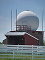 Radiosounding shed near the office

