[3]
Name on the Register
[4]
Image
Date listed
[5]
Location
City or town
Description
1
George and Mabel Anderson House
George and Mabel Anderson House
October 15, 2014 (
#14000862 ) 63 North 200 East
41°30′43″N 112°00′46″W / 41.5119°N 112.0127°W / 41.5119; -112.0127 (George and Mabel Anderson House )
Brigham City
2
Martin Anderson House
Martin Anderson House
January 23, 2003 (
#02001735 ) 105 North 300 West
41°30′48″N 112°01′12″W / 41.513333°N 112.02°W / 41.513333; -112.02 (Martin Anderson House )
Brigham City
3
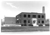
Bear River High School Science Building
Bear River High School Science Building
April 1, 1985 (
#85000797 ) 1450 South Main Street
41°43′33″N 112°09′43″W / 41.725833°N 112.161944°W / 41.725833; -112.161944 (Bear River High School Science Building )
Garland
4
Box Elder County Courthouse
Box Elder County Courthouse
April 7, 1988 (
#88000399 ) 1 North Main Street
41°30′38″N 112°00′51″W / 41.510556°N 112.014167°W / 41.510556; -112.014167 (Box Elder County Courthouse )
Brigham City
5
Box Elder Stake Tabernacle
Box Elder Stake Tabernacle
May 14, 1971 (
#71000840 ) Main Street between 2nd and 3rd South streets
41°30′20″N 112°00′51″W / 41.505556°N 112.014167°W / 41.505556; -112.014167 (Box Elder Stake Tabernacle )
Brigham City
6
Brigham City Carnegie Library
Brigham City Carnegie Library
October 25, 1984 (
#84000143 ) 26 East Forest Street
41°30′39″N 112°00′51″W / 41.510833°N 112.014167°W / 41.510833; -112.014167 (Brigham City Carnegie Library )
Brigham City
7
Brigham City Fire Station/City Hall
Brigham City Fire Station/City Hall
April 7, 1988 (
#88000389 ) 6 North Main Street
41°30′39″N 112°00′53″W / 41.510833°N 112.014722°W / 41.510833; -112.014722 (Brigham City Fire Station/City Hall )
Brigham City
8
Brigham City Historic District
Upload image June 5, 2023 (
#100008770 ) Roughly bounded by 700 South, 500 East, 500 North and 300 and 500 West Sts.
41°30′36″N 112°00′57″W / 41.5101°N 112.0157°W / 41.5101; -112.0157 (Brigham City Historic District )
Brigham City
9
Brigham City Mercantile and Manufacturing Association Mercantile Store
Brigham City Mercantile and Manufacturing Association Mercantile Store
January 24, 1990 (
#89000453 ) 5 North Main Street
41°30′39″N 112°00′56″W / 41.510833°N 112.015556°W / 41.510833; -112.015556 (Brigham City Mercantile and Manufacturing Association Mercantile Store )
Brigham City
10
Central Pacific Railroad Grade Historic District
Central Pacific Railroad Grade Historic District
May 15, 1987 (
#87000699 ) 87-mile (140 km) segment between the Umbria Junction 9 miles (14 km) east of the
Nevada border, around the northern end of
Great Salt Lake , to the
Golden Spike National Historical Park
41°33′44″N 113°20′40″W / 41.562278°N 113.344444°W / 41.562278; -113.344444 (Central Pacific Railroad Grade Historic District )
Park Valley
11
Alma Compton House
Alma Compton House
April 7, 1988 (
#88000381 ) 142 South 100 East
41°30′25″N 112°00′49″W / 41.506944°N 112.013611°W / 41.506944; -112.013611 (Alma Compton House )
Brigham City
12
Corinne Methodist Episcopal Church
Corinne Methodist Episcopal Church
May 14, 1971 (
#71000842 ) Corner of Colorado Street and 4000 West
41°32′51″N 112°06′40″W / 41.5475°N 112.111111°W / 41.5475; -112.111111 (Corinne Methodist Episcopal Church )
Corinne
13
Cutler Hydroelectric Power Plant Historic District
Cutler Hydroelectric Power Plant Historic District
April 20, 1989 (
#89000280 ) Off
State Route 30 at the
Bear River
41°50′06″N 112°03′08″W / 41.835°N 112.052222°W / 41.835; -112.052222 (Cutler Hydroelectric Power Plant Historic District )
Beaver Dam
14
Elberta Theatre
Elberta Theatre
October 17, 1991 (
#91001544 ) 53 South Main Street
41°30′33″N 112°00′52″W / 41.509167°N 112.014444°W / 41.509167; -112.014444 (Elberta Theatre )
Brigham City
15
Alfred and Marie Fawson House
Alfred and Marie Fawson House
January 27, 2003 (
#02001736 ) 64 South 100 West
41°30′33″N 112°01′02″W / 41.509167°N 112.017222°W / 41.509167; -112.017222 (Alfred and Marie Fawson House )
Brigham City
16
Peter and Anna Christena Forsgren House
Peter and Anna Christena Forsgren House
January 23, 2003 (
#02001737 ) 59 South 100 East
41°30′33″N 112°00′47″W / 41.509167°N 112.013056°W / 41.509167; -112.013056 (Peter and Anna Christena Forsgren House )
Brigham City
17
Fryer Hotel
Fryer Hotel
April 7, 1988 (
#88000379 ) 3274 West 11300 North
41°42′56″N 112°05′46″W / 41.715556°N 112.096111°W / 41.715556; -112.096111 (Fryer Hotel )
Deweyville
18
Garland Carnegie Library
Garland Carnegie Library
October 25, 1984 (
#84000146 ) 86 West Factory Street
41°44′29″N 112°09′46″W / 41.741389°N 112.162778°W / 41.741389; -112.162778 (Garland Carnegie Library )
Garland
19
William and Nettie Glover House
William and Nettie Glover House
December 28, 2000 (
#00001587 ) 106 West 100 North
41°30′48″N 112°01′01″W / 41.513333°N 112.016944°W / 41.513333; -112.016944 (William and Nettie Glover House )
Brigham City
20
Golden Spike National Historic Site
Golden Spike National Historic Site
October 15, 1966 (
#66000080 ) 6200 North 22300 West
41°36′31″N 112°33′20″W / 41.608611°N 112.555556°W / 41.608611; -112.555556 (Golden Spike National Historic Site )
Promontory
21
Granary of the Relief Society
Granary of the Relief Society
January 24, 1990 (
#89000455 ) 100 North 400 East
41°30′46″N 112°00′29″W / 41.5128°N 112.0081°W / 41.5128; -112.0081 (Granary of the Relief Society )
Brigham City
22
Hampton's Ford Stage Stop and Barn
Hampton's Ford Stage Stop and Barn
August 12, 1971 (
#71000841 ) 3605 West Bigler Road
41°47′14″N 112°06′18″W / 41.7872°N 112.105°W / 41.7872; -112.105 (Hampton's Ford Stage Stop and Barn )
Collinston
Now the Old Barn Community Theatre
23
Hogup Cave (42BO36)
Hogup Cave (42BO36)
May 8, 1986 (
#86001016 ) Address Restricted
[6]
Park Valley
A cave showing signs of human occupation from about 6500 BC to AD 1470
24
Holmgren Farmstead
Holmgren Farmstead
April 5, 2001 (
#01000319 ) 460 North 300 East
41°42′59″N 112°09′31″W / 41.7164°N 112.1586°W / 41.7164; -112.1586 (Holmgren Farmstead )
Tremonton
25
Christian and Annie Holst House
Christian and Annie Holst House
January 27, 2003 (
#02001738 ) 495 South 200 East
41°30′04″N 112°00′42″W / 41.5011°N 112.0117°W / 41.5011; -112.0117 (Christian and Annie Holst House )
Brigham City
26
Hotel Brigham
Hotel Brigham
October 17, 1991 (
#91001543 ) 13 and 17 West Forest Street
41°30′37″N 112°00′55″W / 41.5103°N 112.0153°W / 41.5103; -112.0153 (Hotel Brigham )
Brigham City
27
Howard Hotel
Howard Hotel
October 7, 1994 (
#94001209 ) 35 South Main Street
41°30′35″N 112°00′53″W / 41.5097°N 112.0147°W / 41.5097; -112.0147 (Howard Hotel )
Brigham City
28
Nels and Minnie Jenson House
Nels and Minnie Jenson House
December 28, 2000 (
#00001588 ) 136 East 100 South
41°30′28″N 112°00′45″W / 41.5078°N 112.0125°W / 41.5078; -112.0125 (Nels and Minnie Jenson House )
Brigham City
29
Jeppson-Reeder House
Jeppson-Reeder House
February 27, 2003 (
#03000082 ) 631 North Main Street
41°31′25″N 112°00′55″W / 41.5236°N 112.0153°W / 41.5236; -112.0153 (Jeppson-Reeder House )
Brigham City
30
Knudson Brothers Building
Knudson Brothers Building
July 16, 1992 (
#92000893 ) 63 South Main Street
41°30′34″N 112°00′52″W / 41.5094°N 112.0144°W / 41.5094; -112.0144 (Knudson Brothers Building )
Brigham City
31
Jonathan and Jennie Knudson House
Jonathan and Jennie Knudson House
December 28, 2000 (
#00001583 ) 48 South 100 East
41°30′32″N 112°00′49″W / 41.5089°N 112.0136°W / 41.5089; -112.0136 (Jonathan and Jennie Knudson House )
Brigham City
32
Lower Bear River Archeological Discontiguous District
Upload image February 13, 1986 (
#86000249 ) Address Restricted
[6]
Brigham City
33
Mountain States Telephone and Telegraph Building
Mountain States Telephone and Telegraph Building
December 27, 1996 (
#96001530 ) 20 East 100 South
41°30′28″N 112°00′52″W / 41.5078°N 112.0144°W / 41.5078; -112.0144 (Mountain States Telephone and Telegraph Building )
Brigham City
34
Oregon Short Line Depot
Oregon Short Line Depot
July 16, 1992 (
#92000891 ) 800 West and Forest Street
41°30′37″N 112°01′43″W / 41.5103°N 112.0286°W / 41.5103; -112.0286 (Oregon Short Line Depot )
Brigham City
35
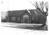
Plymouth School
Plymouth School
April 9, 1986 (
#86000733 ) 135 South Main Street
41°52′31″N 112°08′45″W / 41.8753°N 112.1458°W / 41.8753; -112.1458 (Plymouth School )
Plymouth
36
A. N. Tanner House
A. N. Tanner House
February 11, 1982 (
#82004107 ) Grouse Creek Road
41°42′09″N 113°53′30″W / 41.7026°N 113.8917°W / 41.7026; -113.8917 (A. N. Tanner House )
Grouse Creek
37
Thompson-Hansen House
Thompson-Hansen House
December 23, 1994 (
#94001474 ) 120 North Main Street
41°30′54″N 112°00′51″W / 41.515°N 112.0142°W / 41.515; -112.0142 (Thompson-Hansen House )
Brigham City
38
Transcontinental Railroad Grade
Transcontinental Railroad Grade
December 8, 1994 (
#94001423 ) Roughly from 6 miles (9.7 km) west of Corinne running approximately 13 miles (21 km) along
State Route 83
41°36′55″N 112°20′41″W / 41.6153°N 112.3448°W / 41.6153; -112.3448 (Transcontinental Railroad Grade )
Corinne
39
Tremonton Historic District
Upload image April 26, 2021 (
#100006013 ) Roughly bounded by 600 South, 400 West, 800 North, and 300 East
41°42′42″N 112°09′58″W / 41.7118°N 112.1661°W / 41.7118; -112.1661 (Tremonton Historic District )
Tremonton
40
Union Block
Union Block
October 17, 1991 (
#91001545 ) 57 South Main Street
41°30′32″N 112°00′52″W / 41.5089°N 112.0144°W / 41.5089; -112.0144 (Union Block )
Brigham City
41
Washakie LDS Ward Chapel
Washakie LDS Ward Chapel
June 3, 1998 (
#98000641 ) Along Samaria Lake Canal
41°56′38″N 112°13′06″W / 41.9439°N 112.2183°W / 41.9439; -112.2183 (Washakie LDS Ward Chapel )
Washakie
42
William L. and Mary Watkins House
William L. and Mary Watkins House
May 2, 2001 (
#01000471 ) 74 North 100 East
41°30′44″N 112°00′47″W / 41.5122°N 112.0131°W / 41.5122; -112.0131 (William L. and Mary Watkins House )
Brigham City
43
Willard Historic District
Willard Historic District
June 25, 1974 (
#74001933 ) Roughly bounded by 200 West, 200 North, 100 East, and 200 South streets
41°24′33″N 112°02′09″W / 41.4092°N 112.0358°W / 41.4092; -112.0358 (Willard Historic District )
Willard