| National History Park | |
|---|---|
| Pak nasyonal istorik - Sitadèl, Sansousi, Ramye Parc national historique Citadelle Sans-Souci Ramiers | |
IUCN category IV (habitat/species management area)
[1] | |
.jpg) | |
 | |
| Location | Haiti |
| Coordinates | 19°34′25″N 72°14′39.1″W / 19.57361°N 72.244194°W |
| Area | 25.28 km2 (9.76 sq mi) [2] |
| Established | 1968 |
National History Park ( Haitian Creole: Pak nasyonal istorik, French: Parc national historique) is a national park in Haiti established on 1968. It is located in Milot. It was declared as a UNESCO World Heritage Site in 1982. [1] [3]
The park consists mainly of the ruins of the Sans-Souci Palace, the Citadelle Laferrière and the buildings at Ramiers.
Gallery
-
 National History Park
 -
 National History Park
 -
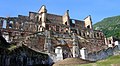 Sans-Souci Palace
 -
 Sans-Souci Palace
 -
 Citadelle Laferrière
 -
 Citadelle Laferrière
 -
 Citadelle Laferrière
 -
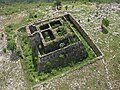 The Ramiers
.jpg)
.jpg)


.jpg)


See also
References
- ^ a b "National History Park – Citadel, Sans Souci, Ramiers". UNESCO World Heritage Convention. United Nations Educational Scientific and Cultural Organization. Retrieved 26 January 2023.
- ^ "La Citadelle, Sans Souci, Ramiers". World Database of Protected Areas. UNEP-WCMC. Retrieved 26 January 2023.
- ^ "National History Park". World Heritage Site. Retrieved 26 January 2023.
External links
- UNESCO World Heritage listing for the National History Park – Citadel, Sans Souci, Ramiers