Nankou Area
南口地区 Nankou Town (南口镇) | |
|---|---|
 Yilu Garden Scenic Area in Longhutai Village, Nankou | |
.png) Location of Nankou Area within
Changping District | |
 Nankou Area  Nankou Area | |
| Coordinates: 40°14′43″N 116°07′43″E / 40.24528°N 116.12861°E | |
| Country | China |
| Municipality | Beijing |
| District | Changping |
| Village-level Divisions | 11
communities 28 villages |
| Area | |
| • Total | 197.6 km2 (76.3 sq mi) |
| Elevation | 86 m (282 ft) |
| Population (2020) | |
| • Total | 82,146 |
| • Density | 420/km2 (1,100/sq mi) |
| Time zone | UTC+8 ( China Standard) |
| Postal code | 102208 |
| Area code | 010 |
Nankou Area ( simplified Chinese: 南口地区; traditional Chinese: 南口地區; pinyin: Nánkǒu Dìqū) is an area and a town situated on the northwestern corner of Changping District, Beijing, China. Bounded by part of Taihang Mountain Range in its north and west, Nankou borders Badaling and Jingzhuang Towns in its north, Chengnan Subdistrict and Shisanling Town in its east, Machikou and Liucun Towns in its south, and Ruiyunguan Township in its west. In 2020, it had 82,146 people under its administration. [1]
The area got its name Nankou ( Chinese: 南口; lit. 'Southern Gate'), from a fortified pass south of Juyong Pass. [2]
History
| Time | Status | Belonged to |
|---|---|---|
| Ming and Qing dynasties | Nankou Village | Yanqing County |
| 1912–1949 | Nankou Town | Co-administered by Yanqing and Changping Counties |
| 1949–1950 | Changping County | |
| 1950–1953 | 3rd District | |
| 1953–1958 | Nankou Town | |
| 1958–1979 | Nankou Commune | |
| 1979–1983 | Nankouzhen Commune | |
| 1983–1987 | Nankou Township | |
| 1987–1990 | Nankou Town | |
| 1990–1997 | Nankou Town
Daonan Town | |
| 1997–1999 | Nankou Town (Integrated Taowa Township in 1997) | |
| 1999–present | Nankou Area (Nankou Town) (Integrated Nankou Farm and part of Tulou Township in 1999) | Changping District |
Administrative divisions
As of 2021, Nankou Area had 39 subdivisions within its borders, composed of 11 communities, and 28 villages: [3]
| Administrative Division Code | Subdisvision Names | Name Transliteration | Type |
|---|---|---|---|
| 110114002001 | 十一条 | Shiyitiao | Community |
| 110114002004 | 兴隆街 | Xinglongjie | Community |
| 110114002006 | 隆盛街 | Longshengjie | Community |
| 110114002008 | 水厂路 | Shuichanglu | Community |
| 110114002012 | 南口村 | Nankoucun | Community |
| 110114002013 | 新兴路 | Xinxinglu | Community |
| 110114002014 | 玻璃公司 | Boli Gongsi | Community |
| 110114002015 | 南厂东 | Nanchang Dong | Community |
| 110114002016 | 南厂西 | Nanchang Xi | Community |
| 110114002017 | 保温瓶公司 | Baowenping Gongsi | Community |
| 110114002018 | 南农 | Nannong | Community |
| 110114002201 | 太平庄 | Taipingzhuang | Village |
| 110114002202 | 虎峪 | Huyu | Village |
| 110114002203 | 陈庄 | Chenzhuang | Village |
| 110114002204 | 红泥沟 | Hongnigou | Village |
| 110114002205 | 雪山 | Xueshan | Village |
| 110114002206 | 龙虎台 | Longhutai | Village |
| 110114002207 | 燕磨峪 | Yanmoyu | Village |
| 110114002208 | 七间房 | Qijianfang | Village |
| 110114002209 | 辛力庄 | Xinlizhuang | Village |
| 110114002210 | 南口 | Nankou | Village |
| 110114002211 | 龙潭 | Longtan | Village |
| 110114002212 | 居庸关 | Juyuguan | Village |
| 110114002213 | 羊台子 | Yangtaizi | Village |
| 110114002214 | 马庄 | Mazhuang | Village |
| 110114002215 | 南口镇 | Nankouzhen | Village |
| 110114002216 | 马坊 | Mafang | Village |
| 110114002217 | 后桃洼 | Hou Taowa | Village |
| 110114002218 | 前桃洼 | Qian Taowa | Village |
| 110114002219 | 长水峪 | Changshuiyu | Village |
| 110114002220 | 檀峪 | Tanyu | Village |
| 110114002221 | 王庄 | Wangzhuang | Village |
| 110114002222 | 曹庄 | Caozhuang | Village |
| 110114002223 | 花塔 | Huata | Village |
| 110114002224 | 兴隆口 | Xinglongkou | Village |
| 110114002225 | 新元 | Xinyuan | Village |
| 110114002226 | 东李庄 | Dong Lizhuang | Village |
| 110114002227 | 西李庄 | Xi Lizhuang | Village |
| 110114002228 | 响潭 | Xiangtan | Village |
Gallery
-
 Juyong Pass and surrounding section of the Great Wall, 2012
 -
 Part of Beijing-Lhasa Expressway near Nankou, 2016
 -
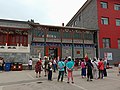 Entrance of Yilu Garden, 2018
 -
 Beijing Vacuum Flask Industrial Company, 2020
.jpg)


.jpg)
Transport
See also
References
- ^ "北京市昌平区第七次全国人口普查公报". bj.bjd.com.cn (in Chinese (China)). Retrieved 2022-10-18.
- ^ a b 李立国; 李万钧; 吴世民, eds. (2013). 中华人民共和国政区大典, 北京市卷. Beijing: 中国社会出版社. ISBN 978-7-5087-4058-4. OCLC 910451741.
- ^ "2021年统计用区划代码和城乡划分代码". www.stats.gov.cn. Retrieved 2022-10-19.
![]() Media related to
Nankou, Beijing at Wikimedia Commons
Media related to
Nankou, Beijing at Wikimedia Commons