You can help expand this article with text translated from
the corresponding article in German. (April 2020) Click [show] for important translation instructions.
|
Nagel | |
|---|---|
 View of Nagel over the Nagel Lake | |
 Coat of arms | |
Location of Nagel within Wunsiedel im Fichtelgebirge district 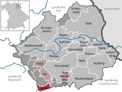 | |
 Nagel  Nagel | |
| Coordinates: 49°59′N 11°55′E / 49.983°N 11.917°E | |
| Country | Germany |
| State | Bavaria |
| Admin. region | Oberfranken |
| District | Wunsiedel im Fichtelgebirge |
| Municipal assoc. | Tröstau |
| Subdivisions | 7 Ortsteile |
| Government | |
| • Mayor (2020–26) | Helmut Voit [1] ( CSU) |
| Area | |
| • Total | 7.79 km2 (3.01 sq mi) |
| Elevation | 580 m (1,900 ft) |
| Population (2022-12-31)
[2] | |
| • Total | 1,737 |
| • Density | 220/km2 (580/sq mi) |
| Time zone | UTC+01:00 ( CET) |
| • Summer ( DST) | UTC+02:00 ( CEST) |
| Postal codes | 95697 |
| Dialling codes | 09236 |
| Vehicle registration | WUN |
| Website | www.erholungsort-nagel.de |
Nagel is a municipality in the district of Wunsiedel in Bavaria in Germany.
References
- ^ Liste der ersten Bürgermeister/Oberbürgermeister in kreisangehörigen Gemeinden, Bayerisches Landesamt für Statistik, 15 July 2021.
- ^ Genesis Online-Datenbank des Bayerischen Landesamtes für Statistik Tabelle 12411-003r Fortschreibung des Bevölkerungsstandes: Gemeinden, Stichtag (Einwohnerzahlen auf Grundlage des Zensus 2011).
Towns and municipalities in
Wunsiedel (district) | ||
|---|---|---|
|
| This Wunsiedel district location article is a stub. You can help Wikipedia by expanding it. |