| Mynydd Mawr | |
|---|---|
 Mynydd Mawr from
Trum y Ddysgl | |
| Highest point | |
| Elevation | 698 m (2,290 ft) |
| Prominence | 462 m (1,516 ft) |
| Parent peak | Moel Hebog |
| Listing | Marilyn, Hewitt, Nuttall |
| Naming | |
| English translation | big mountain |
| Language of name | Welsh |
| Pronunciation | Welsh: [ˈmənɨð ˈmaur] |
| Geography | |
| Location | Gwynedd, Wales |
| Parent range | Snowdonia |
| OS grid | SH539546 |
| Topo map | OS Landranger 115 |
Mynydd Mawr ( Welsh for big mountain) is a mountain in Snowdonia, North Wales, approximately 7 km (4.3 mi) west of Snowdon itself, overlooking Llyn Cwellyn and being the northern outlier of the Moel Hebog group. A popular ascent starts from Rhyd Ddu. On its western flank are the remains of ancient settlements and field systems. The profile of Mynydd Mawr from the north is often thought to resemble an elephant lying down, and consequently the mountain is often colloquially also called "Yr Eliffant" ('The Elephant'), or "Elephant Mountain" by non-Welsh speakers. [1]
.jpg)
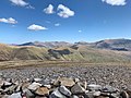
The summit offers extensive views, on a clear day to the west, the views extend to the Lleyn Peninsula and Caernarfon Bay, from the north-west includes Anglesey. To the north lies Moel Eilio and to the east is Moel Hebog and Snowdon. On exceptionally clear days, the Wicklow Mountains in Ireland can be seen westwards across the Irish Sea from the summit.
-
 Mynydd Mawr with Cwellyn
 -
 Mynydd Mawr and the Glyderau
 -
 Mynydd Mawr from Cwellyn


References
- ^ Nuttall, John; Nuttall, Anne (1999). The Mountains of England & Wales – Volume 1: Wales (2nd ed.). Milnthorpe, Cumbria: Cicerone. ISBN 1-85284-304-7.
External links
- Walking guide and photographs here and here.
- www.geograph.co.uk : photos of Mynydd Mawr and surrounding area

53°04′07″N 4°10′55″W / 53.06860°N 4.18200°W
|
| This Gwynedd location article is a stub. You can help Wikipedia by expanding it. |