Mulberry Street Bridge | |
|---|---|
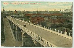
 Postcard of the Mulberry Street Bridge as seen from
Allison Hill in 1913 | |
| Coordinates | 40°15′40″N 76°52′30″W / 40.2612°N 76.8750°W |
| Carries | Motor vehicles and pedestrians |
| Crosses | Cameron Street, Paxton Creek |
| Locale | Harrisburg, Pennsylvania |
| Characteristics | |
| Total length | 584 feet (178 m) |
| Width | 30.4 feet (9.3 m) |
| History | |
| Opened | 1907-09 rehabilitated 1957 |
| Location | |
|
| |
The Mulberry Street Bridge is an American concrete arch bridge that spans Cameron Street and Paxton Creek in Harrisburg, Pennsylvania.
History and architectural features
This bridge is the second to be constructed at the current site to connect the Allison Hill neighborhood of East Harrisburg to Downtown. It replaced an iron and fire-prone, wood-decked structure erected in 1891, which was heralded as a unifier of a "Greater Harrisburg." [1] The concrete replacement bridge that was built in 1909 was a marvel at the time, and is eligible to be listed on the National Register of Historic Places. [2]
See also
References
- ^ City of Harrisburg (2004). "Visitors Guide to Downtown Harrisburg". harrisburgpa.gov. Archived from the original on 2007-03-14. Retrieved 2006-12-23.
- ^ Baughn, James (2006). "Mulberry Street Ramp Bridge". Historic Bridges of the United States. Retrieved 2006-12-23.
External links
- Historic American Engineering Record (HAER) No. PA-497, " Mulberry Street Viaduct, Spanning Paxton Creek & Cameron Street (State Route 230) at Mulberry Street (State Route 3012), Harrisburg, Dauphin County, PA", 5 photos, 14 data pages, 1 photo caption page