| Mount Victoria | |
|---|---|
 Mount Victoria seen from
Oriental Bay | |
| Highest point | |
| Elevation | 196 m (643 ft) |
| Coordinates | 41°17′46″S 174°47′46″E / 41.296056°S 174.796083°E |
| Geography | |
| Location | North Island, New Zealand |
Mount Victoria, also known as Matairangi and colloquially as Mt Vic, is a prominent 196-metre (643 ft) hill immediately to the east of central Wellington, New Zealand. About 4 kilometres due south is a spur named Mount Albert and the two are linked by a ridge. Mount Victoria gives its name to the suburb of Mount Victoria to the west.
History
Mount Victoria's original Māori name is Tangi Te Keo, [1] though Matairangi is also used. [2] The first name derives from a legend in which two taniwha tried to escape from Wellington Harbour which was then an enclosed lake. One taniwha became stranded and died, and its spirit turned into a bird named Te Keo, which flew to the top of the mountain and mourned (tangi). [1] The second name translates as "to examine the sky". [3]
In 1931, the Mount Victoria Tunnel was opened, [4] connecting the suburbs of Mount Victoria and Hataitai.
Television broadcasts began in Wellington on 1 July 1961, broadcast from a transmitter atop Mount Victoria. In 1967, the Mount Victoria transmitter was replaced with a more powerful transmitter at Mount Kaukau. [5]
Amenities
Mount Victoria is a popular walk for tourists and Wellingtonians alike, as from the summit one can see most of Wellington. There are numerous mountain bike and walking tracks on the hill.
Gallery
-
 Mount Victoria in 1885
 -
 The New Zealand National Memorial to Rear Admiral Richard E. Byrd
 -
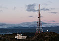 The Mount Victoria Transmission Tower
 -
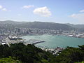 View of Wellington City from Mount Victoria
.jpg)

.jpg)
.jpg)
References
- ^ a b Te Ara: The New Zealand Encyclopedia. Story: Taniwha. http://www.teara.govt.nz/en/taniwha/page-2
- ^ Wellington City Council (1 September 2016). "Mount Victoria / Matairangi Master Plan".
- ^ Wright + Associates (June 2015). "Mount Victoria - Matairangi Master Plan - June 2015" (PDF). Wellington City Council. Retrieved 1 September 2016.
- ^ O'Neil, Andrea (13 April 2015). "Wellington's Mt Victoria 'tooting tunnel' a tribute to murdered teen". Stuff. Retrieved 18 April 2023.
- ^ "Parliamentary Debates (Hansard)". Vol. 351. New Zealand Parliament. 28 June 1967. p. 1394.