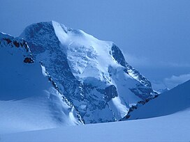
| Mount Sir Sandford | |
|---|---|
 Mount Sir Sandford from Gothics Glacier | |
| Highest point | |
| Elevation | 3,519 m (11,545 ft) [1] |
| Prominence | 2,707 m (8,881 ft) [1] |
| Listing | |
| Coordinates | 51°39′24″N 117°52′04″W / 51.65667°N 117.86778°W [2] |
| Geography | |
| District | Kootenay Land District |
| Parent range | Sir Sandford Range |
| Topo map | NTS 82N12 Mount Sir Sandford [2] |
| Climbing | |
| First ascent | 1912 [3] |
| Easiest route | remote glacier/ice/rock climb |
Mount Sir Sandford is the highest mountain of the Sir Sandford Range and the highest mountain in the Selkirk Mountains of southeastern British Columbia, Canada. It is the 12th highest peak in the province. The mountain was named after Sir Sandford Fleming, a railway engineer for the Canadian Pacific Railway.
The mountain was first summited in 1912 after several attempts in prior years by a party of four, led by Edward W. D. Holway and including Howard Palmer, Edward Feuz Jr. and Rudolph Aemmer. [4]
See also
References
- ^ a b "British Columbia and Alberta: The Ultra-Prominence Page". Peaklist.org. Retrieved 2013-01-21.
- ^ a b "Mount Sir Sandford". BC Geographical Names. Retrieved 2019-05-12.
- ^ "Mount Sir Sandford". Bivouac.com. Retrieved 2019-05-12.
- ^ Howard Palmer, Edward W. D. Holway: A Pioneer of the Canadian Alps. (University of Minnesota Press, 1931) pp. 37-38.
External links
- "Mount Sir Sandford, British Columbia" on Peakbagger
- Mount Sir Sandford aerial photo: PBase
