| Mount Kukak | |
|---|---|
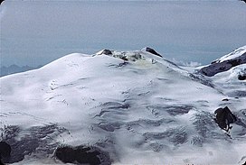
 Fumarolic activity at Kukak volcano in August 2003 | |
| Highest point | |
| Elevation | 6,703 ft (2,043 m) [1] |
| Listing | List of volcanoes in the United States |
| Coordinates | 58°27′10″N 154°21′18″W / 58.45278°N 154.35500°W [1] |
| Geography | |
| Geology | |
| Mountain type | Stratovolcano |
| Volcanic arc/ belt | Aleutian Arc |
| Last eruption | Unknown |
Mount Kukak is an almost completely ice-covered stratovolcano on the Alaska Peninsula of Alaska, United States. Although the last eruption from Mount Kukak is unknown, it displays vigorous fumarolic activity. [1]
References
- ^ a b c "Kukak". Global Volcanism Program. Smithsonian Institution. Retrieved 2008-12-29.
