| Mount Ellsworth | |
|---|---|
 South aspect | |
| Highest point | |
| Elevation | 8,235 ft (2,510 m) [1] |
| Prominence | 2,915 ft (888 m) [1] |
| Parent peak | Mount Hillers (10,737 ft) [2] |
| Isolation | 9.89 mi (15.92 km) [2] |
| Coordinates | 37°44′46″N 110°37′12″W / 37.7462032°N 110.6200447°W [3] |
| Geography | |
 Mount Ellsworth Location in Utah  Mount Ellsworth Mount Ellsworth (the United States) | |
| Location | Garfield County, Utah, U.S. |
| Parent range | Henry Mountains |
| Topo map | USGS Ticaboo Mesa |
| Geology | |
| Age of rock | Oligocene |
| Mountain type | Laccolith |
| Type of rock | Igneous and sandstone |
| Climbing | |
| Easiest route | class 2 scrambling [2] |
Mount Ellsworth is an 8,235-foot (2,510 m) elevation summit located in Garfield County, Utah, United States. [3] Mount Ellsworth is part of the Henry Mountains. It is situated in a dry, rugged, and sparsely settled region west of Glen Canyon National Recreation Area, on primitive land administered by the Bureau of Land Management. Precipitation runoff from this mountain drains into tributaries of the nearby Colorado River, which here is Lake Powell eight miles to the east of this mountain.
History
The American geologist Grove Karl Gilbert surveyed this area in 1875 and 1876, and published his findings in 1879 as a monograph, The Geology of the Henry Mountains. The term laccolith was first applied as laccolite by Gilbert after his study of intrusions of diorite in the Henry Mountains. [4] Mount Ellsworth's name appeared on an 1875 map, but the origin is a mystery. [5] One possibility is Elmer E. Ellsworth, (1837–1861). [6] Gilbert did name nearby Mount Holmes, four miles to the northeast.
Climate
Spring and fall are the most favorable seasons to visit Mount Ellsworth. According to the Köppen climate classification system, it is located in a Cold semi-arid climate zone, which is defined by the coldest month having an average mean temperature below 32 °F (0 °C), and at least 50% of the total annual precipitation being received during the spring and summer. This desert climate receives less than 10 inches (250 millimeters) of annual rainfall, and snowfall is generally light during the winter.
Gallery
-
-

-
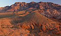
 Aerial view, south at top of frame
 -
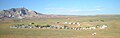 Ticaboo, Utah, with Ellsworth to left
 -
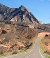 Nearby Bullfrog, Utah is named for this feature on Mt. Ellsworth that resembles a bullfrog, as seen from southbound Highway 276


See also
References
- ^ a b "Mount Ellsworth". Peakbagger.com. Retrieved 2020-09-18.
- ^ a b c "Ellsworth, Mount - 8,235' UT". listsofjohn.com. Retrieved 2020-09-18.
- ^ a b "Mount Ellsworth". Geographic Names Information System. United States Geological Survey, United States Department of the Interior. Retrieved 2020-09-18.
- ^ Aber, James S. "Grove Karl Gilbert". academic.emporia.edu. Retrieved 29 December 2018.
- ^ Pete Klocki and Tiffany Mapel, A Wild Redhead Tamed: A Brief History of the Colorado River and Lake Powell, 2009, page 85.
- ^ Pete Klocki and Tiffany Mapel, A Wild Redhead Tamed: A Brief History of the Colorado River and Lake Powell, 2009, page 86.
External links
- Weather forecast: Mount Ellsworth