| Mount Clark | |
|---|---|
 | |
| Highest point | |
| Elevation | 7,528 ft (2,295 m) [1] |
| Prominence | 608 ft (185 m) [1] |
| Parent peak | Mount Johnson [2] |
| Isolation | 0.33 mi (0.53 km) [2] |
| Coordinates | 47°50′08″N 123°13′54″W / 47.8355277°N 123.2317826°W [3] |
| Geography | |
 Mount Clark Location of Mount Clark in Washington  Mount Clark Mount Clark (the United States) | |
| Country | United States |
| State | Washington |
| County | Jefferson |
| Protected area | Olympic National Park |
| Parent range | Olympic Mountains |
| Topo map | USGS Mount Deception |
| Geology | |
| Age of rock | Eocene |
| Type of rock | basalt |
| Climbing | |
| Easiest route | class 3 scrambling [4] |
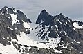
Mount Clark is a 7,528-foot (2,295-metre) mountain summit located within Olympic National Park in Jefferson County of Washington state. [3] Its nearest higher peak is Sweat Spire (7,580 ft) on Mount Johnson, 0.26 mi (0.42 km) to the southwest, and Mount Walkinshaw is set 0.9 mi (1.4 km) to the north. [1] It is the second highest peak in The Needles range, which is a subrange of the Olympic Mountains, and seventh highest in the Olympic Mountains. [5] The climbing routes on Mt. Clark start at Class 3 scrambling and range up to Class 5.5 via the central South Face. [4] Precipitation runoff from the mountain drains into tributaries of the Dungeness River.
History
The first ascent of the mountain was made on August 21, 1940, by George R. Martin and Elvin Johnson who dubbed the peak Mt. Belvedere. [6]
The mountain was officially named in 1965 to honor Irving M. Clark (1882-1960), a Seattle conservationist and leader in the establishment of Olympic National Park. [6]
Climate
Based on the Köppen climate classification, Mount Clark is located in the marine west coast climate zone of western North America. [7] Weather fronts originating in the Pacific Ocean travel northeast toward the Olympic Mountains. As fronts approach, they are forced upward by the peaks ( orographic lift), causing them to drop their moisture in the form of rain or snow. As a result, the Olympics experience high precipitation, especially during the winter months in the form of snowfall. [8] Because of maritime influence, snow tends to be wet and heavy, resulting in avalanche danger. During winter months weather is usually cloudy, but due to high pressure systems over the Pacific Ocean that intensify during summer months, there is often little or no cloud cover during the summer. [8] The months of July through September offer the most favorable weather for climbing.
Gallery
-
 Mount Clark centered, with Sweat Spire and Mt. Johnson (left)
 -
 The Needles and Mount Clark


See also
References
- ^ a b c "Mount Clark". Peakbagger.com.
- ^ a b "Clark, Mount – 7,528' WA". listsofjohn.com. Retrieved 2024-04-13.
- ^ a b "Mount Clark". Geographic Names Information System. United States Geological Survey, United States Department of the Interior. Retrieved 2019-01-21.
- ^ a b Mount Clark at Climbers Guide Olympics
- ^ Peakbagger Olympic Mountain 6500-foot Peaks
- ^ a b Parratt, Smitty (1984). Gods and Goblins: A Field Guide to Place Names of Olympic National Park (1st ed.).
- ^ Peel, M. C.; Finlayson, B. L.; McMahon, T. A. (2007). "Updated world map of the Köppen−Geiger climate classification". Hydrol. Earth Syst. Sci. 11: 1633–1644. ISSN 1027-5606.
- ^ a b McNulty, Tim (2009). Olympic National Park: A Natural History. Seattle, Washington: University of Washington Press.
External links
- "Olympic National Park". National Park Service.
- Mount Clark weather: Mountain Forecast