Mosquero, New Mexico | |
|---|---|
 | |
 Location of Mosquero, New Mexico | |
 Mosquero, New Mexico Location in the United States | |
| Coordinates: 35°46′35″N 103°57′26″W / 35.77639°N 103.95722°W | |
| Country | United States |
| State | New Mexico |
| Counties | Harding, San Miguel |
| Area | |
| • Total | 1.00 sq mi (2.58 km2) |
| • Land | 1.00 sq mi (2.58 km2) |
| • Water | 0.00 sq mi (0.00 km2) |
| Elevation | 5,591 ft (1,704 m) |
| Population | |
| • Total | 98 |
| • Density | 98.20/sq mi (37.92/km2) |
| Time zone | UTC-7 ( Mountain (MST)) |
| • Summer ( DST) | UTC-6 (MDT) |
| ZIP code | 87733 |
| Area code | 575 |
| FIPS code | 35-50300 |
| GNIS feature ID | 0892254 |
| Website | www.villageofmosquero.com/ |
Mosquero is a village in Harding and San Miguel counties in the U.S. state of New Mexico. The population was 93 at the 2010 census, [3] down from 120 in 2000. It is the county seat of Harding County; [4] only a small portion of the village extends into San Miguel County.
Geography
Mosquero is located at 35°46′35″N 103°57′26″W / 35.77639°N 103.95722°W (35.776293, -103.957133). [5] New Mexico State Road 39 passes through the village, leading southeast 50 miles (80 km) to Logan and northwest 18 miles (29 km) to Roy.
According to the United States Census Bureau, the village has a total area of 1.0 square mile (2.6 km2), all land. [3]
History
The site was a water stop along the Dawson Railway, built in 1902 from Tucumcari to Dawson. [6] The name in Spanish translates as "swarm of flies" , reputedly from the flies that were drawn to carcasses of bison hunted by local native tribes. The village was founded in 1908 by Benjamin Brown, and a post office was established here in that year. [7]
The community developed as a farming and stock-raising and shipping point, with a dry ice plant, using carbon dioxide from local wells drilled into the Bravo Dome carbon dioxide gas field, which lies beneath Harding and Union counties. The railroad, absorbed into the Southern Pacific, was removed in 1950 and the population dwindled after the dry ice plant was destroyed. [8]
Demographics
| Census | Pop. | Note | %± |
|---|---|---|---|
| 1930 | 401 | — | |
| 1940 | 742 | 85.0% | |
| 1950 | 583 | −21.4% | |
| 1960 | 310 | −46.8% | |
| 1970 | 244 | −21.3% | |
| 1980 | 197 | −19.3% | |
| 1990 | 164 | −16.8% | |
| 2000 | 120 | −26.8% | |
| 2010 | 93 | −22.5% | |
| 2020 | 98 | 5.4% | |
| U.S. Decennial Census [9] [2] | |||
As of the census [10] of 2000, there were 120 people, 60 households, and 33 families residing in the village. The population density was 120.8 people per square mile (46.6 people/km2). There were 86 housing units at an average density of 86.5 per square mile (33.4/km2). The racial makeup of the village was 70.00% White, 25.83% from other races, and 4.17% from two or more races. Hispanic or Latino of any race were 77.50% of the population.
There were 60 households, out of which 16.7% had children under the age of 18 living with them, 45.0% were married couples living together, 8.3% had a female householder with no husband present, and 45.0% were non-families. 41.7% of all households were made up of individuals, and 23.3% had someone living alone who was 65 years of age or older. The average household size was 2.00 and the average family size was 2.76.
In the village, the population was spread out, with 17.5% under the age of 18, 4.2% from 18 to 24, 20.0% from 25 to 44, 31.7% from 45 to 64, and 26.7% who were 65 years of age or older. The median age was 51 years. For every 100 females, there were 114.3 males. For every 100 females age 18 and over, there were 110.6 males.
The median income for a household in the village was $25,000, and the median income for a family was $32,917. Males had a median income of $19,167 versus $16,250 for females. The per capita income for the village was $11,915. There were 14.6% of families and 21.6% of the population living below the poverty line, including 41.4% of under eighteens and 22.2% of those over 64.
Notable person
- Donald Enlow, orthodontics scientist
Gallery
-
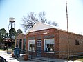 Mosquero post office & water tower
 -
 Goodnight-Loving Trail marker


See also
References
- ^ "ArcGIS REST Services Directory". United States Census Bureau. Retrieved October 12, 2022.
- ^ a b "Census Population API". United States Census Bureau. Retrieved October 12, 2022.
- ^ a b "Geographic Identifiers: 2010 Census Summary File 1 (G001): Mosquero village, New Mexico". American Factfinder. U.S. Census Bureau. Archived from the original on February 13, 2020. Retrieved August 24, 2017.
- ^ "Find a County". National Association of Counties. Retrieved June 7, 2011.
- ^ "US Gazetteer files: 2010, 2000, and 1990". United States Census Bureau. February 12, 2011. Retrieved April 23, 2011.
- ^ Myrick, David, ‘’New Mexico’s Railroads, A Historic Survey’’, University of New Mexico Press 1990. ISBN 0-8263-1185-7
- ^ Pearce, T.M.,editor, New Mexico Place Names, A Geographical Dictionary, University of New Mexico Press 1965. ISBN 0-8263-0082-0
- ^ https://www.villageofmosquero.com/
- ^ "Census of Population and Housing". Census.gov. Retrieved June 4, 2015.
- ^ "U.S. Census website". United States Census Bureau. Retrieved January 31, 2008.
External links
![]() Media related to
Mosquero, New Mexico at Wikimedia Commons
Media related to
Mosquero, New Mexico at Wikimedia Commons
Municipalities and communities of
Harding County, New Mexico, United States | ||
|---|---|---|
| Villages | 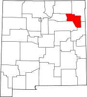 | |
|
Unincorporated communities | ||
| Footnotes | ‡This populated place also has portions in an adjacent county or counties | |
Municipalities and communities of
San Miguel County, New Mexico, United States | ||
|---|---|---|
| City |  | |
| Villages | ||
| CDPs | ||
|
Other communities | ||
| Ghost towns | ||
| Footnotes | ‡This populated place also has portions in an adjacent county or counties | |
| International | |
|---|---|
| National | |