Mosgrove, Pennsylvania | |
|---|---|
Unincorporated community | |
| Coordinates: 40°52′08″N 79°28′31″W / 40.86889°N 79.47528°W | |
| Country | United States |
| State | Pennsylvania |
| County | Armstrong |
| Township | Rayburn |
| Elevation | 978 ft (298 m) |
| Time zone | UTC-5 ( Eastern (EST)) |
| • Summer ( DST) | UTC-4 (EDT) |
| GNIS feature ID | 1181608 [1] |
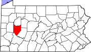
Mosgrove is an unincorporated community in Rayburn Township, Armstrong County, Pennsylvania, United States. [1] The community lies along the east side of the Allegheny River, 7.0 miles (11.3 km) north of Kittanning via Pennsylvania Route 66.
History
A post office called Mosgrove was established in 1886 and remained in operation until 1938. [2]
References
- ^ a b "Mosgrove". Geographic Names Information System. United States Geological Survey, United States Department of the Interior.
- ^ "Post Offices:Pennsylvania, Armstrong County". Jim Forte Postal History. Retrieved November 6, 2018.

