
20°28′S 115°32′E / 20.46°S 115.54°E


The Montebello Islands, also rendered as the Monte Bello Islands, are an archipelago of around 174 small islands (about 92 of which are named) lying 20 km (12 mi) north of Barrow Island and 130 km (81 mi) off the Pilbara coast of north-western Australia. The islands form a marine conservation reserve of 58,331 ha (144,139 acres) administered by the Western Australian Department of Environment and Conservation. The islands were the site of three British atmospheric nuclear weapons tests in 1952 and 1956. [1]
Description
The islands of the archipelago have a collective land area of about 22 km2 (8.5 sq mi). The largest islands, Hermite and Trimouille, have areas of 1,022 ha (2,525 acres) and 522 ha (1,290 acres) respectively. They consist of limestone rock and sand. The rocky parts are dominated by Triodia hummock grassland with scattered shrubs, while the sandy areas support grasses, sedges and shrubs, mainly Acacia. Patches of mangroves grow in sheltered bays and channels of the archipelago, especially at Hermite Island. The climate is hot and arid with an annual average rainfall of about 320 mm. [2]
Wildlife
Birds
The islands have been identified by BirdLife International as an Important Bird Area (IBA) because they support over 1% of the world populations of fairy and roseate terns, and of sooty oystercatchers. [3] Greater crested terns breed there irregularly, sometimes in large numbers. Other birds breeding on the islands include ospreys, white-bellied sea eagles, pied oystercatchers, Caspian terns and bridled terns. The islands support 12–15 breeding pairs of beach stone-curlews. Yellow white-eyes have been recorded. [2]
Mammals
Invasive feral cats and black rats have been eradicated from the islands, allowing endangered rufous hare-wallabies (mala) and Shark Bay mice to be translocated to the islands under the conservation management strategy for these threatened species. [2] They are now common on many of the larger islands.
-
 The islands are an important site for sooty oystercatchers
 -
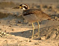 Beach stone-curlews inhabit the islands
 -
 Mala have been introduced to the islands


History
Archaeological remains show that the islands were visited by indigenous Australians until about 8248 BP, when a period of global warming and rising sea levels caused the Montebellos to become separated from the mainland, and forced abandonment. [4] [5]
In 1622 Tryall, an English East India Company-owned East Indiaman, was wrecked on the Tryal Rocks, uncharted submerged rocks about 32 kilometres (20 mi) northwest of the outer edge of the Montebello Islands. The ship's factor Thomas Bright and 35 others sailed a longboat to the Montebello Islands and spent seven days ashore, before sailing the longboat to Bantam in Java. This was the first recorded shipwreck in Australian waters and the first extended stay in Australia by Europeans. [6] [7]
In 1801 Nicolas Baudin, leading a French Navy exploration expedition, named the island group after the Battle of Montebello of 1800, Hermite Island after Admiral Jean-Marthe-Adrien L'Hermite, and Trimouille Island after French general Louis II de la Trémoille.
The islands were economically significant for pearl fishing from the end of the 19th century until the outbreak of the Second World War. [8]
British nuclear weapons tests
The Montebello Islands were the site of three atmospheric nuclear weapon tests by the British military: one in 1952, and two in 1956. [9] [10]
HMS Plym, moored in Main Bay on Trimouille Island, was the site of Operation Hurricane, the first-ever atomic weapon tested by the United Kingdom, on 3 October 1952. [11] [12]
While subsequent British tests were conducted at sites on mainland Australia, in 1956 there were two land-sited tower-mounted tests, on Trimouille and Alpha Islands. [13] The second of these, codenamed " Mosaic G2", was the largest nuclear explosion in Australia, with an official yield of 60 kilotons. Mosaic G2 was later described as an "exceptionally dirty explosion", whose fallout contaminated large areas of mainland Australia, as far away as the Queensland towns of Mount Isa, Julia Creek, Longreach and Rockhampton. [14] [15] [16]
Islands

Of the smaller islands, the largest are:
- North-West Island
- Primrose Island
- Bluebell Island
- Alpha Island
- Crocus Island
- Campbell Island
- Delta Island
- Renewal Island
- Ah Chong Island
There are also 10 named groups of small islets, whose individual islands have not yet been named:
- Corkwood Islands
- Fig Islands
- Hakea Islands
- Jarrah Islands
- Jasmine Islands
- Karri Islands
- Marri Islands
- Minnieritchie Islands
- Mulga Islands
- Quandong Islands
References
- ^ "Management Plan for the Montebello/Barrow Islands Marine Conservation Reserves 2007–2017" (PDF). Perth, WA: Department of Environment and Conservation. 16 January 2018. Retrieved 13 August 2021.
- ^ a b c BirdLife International. (2011). Important Bird Areas factsheet: Montebello Islands. Downloaded from http://www.birdlife.org on 16/08/2011.
- ^ "IBA: Montebello Islands". Birdata. Birds Australia. Retrieved 16 August 2011.
- ^ Manne, Tiina; Veth, Peter (January 2015). "Late Pleistocene and early Holocene exploitation of estuarine communities in northwestern Australia". Quaternary International. 385 (385): 112–123. Bibcode: 2015QuInt.385..112M. doi: 10.1016/j.quaint.2014.12.049.
- ^ Veth, Peter; Aplin, Ken; Wallis, Lynley; Manne, Tiina; Pulsford, Tim; White, Elizabeth; Chappell, Alan (2007). The Archaeology of Montebello Islands, North-West Australia: Late Quaternary foragers on an arid coastline. Oxford: Archaeopress. doi: 10.30861/9781407301037. ISBN 9781407301037. Retrieved 18 May 2023.
- ^ Lee, Ida (April 1934). "The First Sighting of Australia by the English". The Geographical Journal. 83 (4). Royal Geographical Society: 317–321. Bibcode: 1934GeogJ..83..317L. doi: 10.2307/1786489. JSTOR 1786489.
- ^ Sainsbury, W. Noel, ed. (1884). Calendar of State Papers, Colonial Series, East Indies, China and Persia, 1625-1629. London: Longman, Green, Longman & Roberts. p. 13.
- ^ Stansbury, Myra (January 1986). A survey of sites associated with early pearling activities in the Monte Bello Islands, Western Australia (PDF). Fremantle: Department of Maritime Archaeology, Western Australian Maritime Museum. Retrieved 11 August 2021.
- ^ Cooper, M.B.; Hartley, B.M. (April 1979). Residual Radioactive Contamination of the Monte Bello Islands from Nuclear Weapon Tests Conducted in 195 and 1956 (PDF). Australian Radiation Laboratory.
- ^ Benjamin C. Garrett (25 August 2017). Historical Dictionary of Nuclear, Biological, and Chemical Warfare. Rowman & Littlefield Publishers. pp. 202–. ISBN 978-1-5381-0684-6.
- ^ Richard Tykva; Dieter Berg (14 March 2013). Man-Made and Natural Radioactivity in Environmental Pollution and Radiochronology. Springer Science & Business Media. pp. 119–. ISBN 978-94-017-0496-0.
- ^ Michael Wainwright (14 February 2017). Game Theory and Postwar American Literature. Palgrave Macmillan US. pp. 116–. ISBN 978-1-137-60133-9.
- ^ "British Nuclear Testing". Britain's Nuclear Weapons. 23 August 2007. Retrieved 13 August 2021.
- ^ Connor, Steve (24 May 1984). "The nuclear blast that Britain kept secret". New Scientist. London. p. 4. ISSN 0262-4079. Retrieved 13 August 2021.
- ^ Walker, Frank (26 August 2014). Maralinga: The chilling expose of our secret nuclear shame and betrayal of our troops and country. Hachette Australia. pp. 58–. ISBN 978-0-7336-3205-1.
- ^ Cross, Roger. (2001). Fallout. Wakefield Press. (p.179).
Further reading
- Acaster, Ray (1995). "British nuclear testing at the Monte Bello Islands". Early Days Vol. 11, no. 1. pp. 66–80.
- Arnold, Lorna; and Smith, Mark (2006). Britain, Australia and the Bomb: The Nuclear Tests and Their Aftermath. Palgrave MacMillan. ISBN 1-4039-2102-4
- Bird, Peter (1989). Operation Hurricane. Square One Publications: Worcester. (First published in 1953). ISBN 1-872017-10-X
- Burbidge, A. A. (1971). The Fauna and Flora of the Monte Bello Islands. Department of Fisheries and Fauna: Perth.
- Deegan, P. M. (1992). Monte Bello and Lowendal Islands: bibliography, summary report of marine resources. Dept. of Conservation and Land Management: Perth.
- Duyker, Edward (2006). François Péron: An Impetuous Life: Naturalist and Voyager. Miegunyah/MUP: Melbourne. ISBN 978-0-522-85260-8
- Fornasiero, Jean; Monteath, Peter; and West-Sooby, John (2004). Encountering Terra Australis: the Australian voyages of Nicholas Baudin and Matthew Flinders. Wakefield Press: Kent Town, South Australia. ISBN 1-86254-625-8
- Horner, Frank (1987). The French Reconnaissance: Baudin in Australia 1801–1803. Melbourne University Press: Melbourne. ISBN 0-522-84339-5.
- Tuckfield, Trevor (1 August 1951). "The Monte Bello Islands". Walkabout, Vol. 17, No. 8. pp. 33–34.
External links
- Video footage of the Operation Hurricane detonation on Trimouille Island in 1951
- Nicolas Baudin's Scientific Expedition to the Terres Australes by Steve Reynolds – Marine Life Society of South Australia Inc.
- Details of a feral cat eradication program on Hermite Island in 1999
- Nuclear testing details
| International | |
|---|---|
| National | |