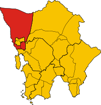
Mondol Seima
ស្រុកមណ្ឌលសីម៉ា | |
|---|---|
 Location in Cambodia | |
| Coordinates: 11°48′46″N 103°00′41″E / 11.8129°N 103.0115°E | |
| Country | |
| Province | Koh Kong |
| Communes | 3 |
| Villages | 13 |
| Population (1998)
[1] | |
| • Total | 12,569 |
| Time zone | +7 |
| Geocode | 0906 |
Mondol Seima District ( Khmer: ស្រុកមណ្ឌលសីម៉ា) is a district ( srok) of Koh Kong Province, in south-western Cambodia. The Kah Bpow River flows through it.
Administration
| Mondol Seima District | |
|---|---|
| Khum (Commune) | Phum (Villages) |
| Bak Khlang | Bak Khlang Muoy, Bak Khlang Pir, Bak Khlang Bei, Boeng Kachhang, Kaoh Pao, Neang Kok, Cham Yeam |
| Peam Krasaob | Peam Krasob Ti Muoy, Peam Krasob Ti Pir |
| Tuol Kokir Leu | Tuol Kokir Kraom, Tuol Kokir Leu, Ta Chat, Kaoh Chak |
Notes
- ^ General Population Census of Cambodia, 1998: Village Gazetteer. National Institute of Statistics. February 2000.

