Mole Lake, Wisconsin | |
|---|---|
Census-designated place | |
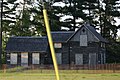
 Welcome sign and houses in Mole Lake | |
 Mole Lake, Wisconsin | |
| Coordinates: 45°28′47″N 88°58′59″W / 45.47972°N 88.98306°W | |
| Country | United States |
| State | Wisconsin |
| County | Forest |
| Area | |
| • Total | 4.160 sq mi (10.77 km2) |
| • Land | 3.698 sq mi (9.58 km2) |
| • Water | 0.462 sq mi (1.20 km2) |
| Elevation | 1,552 ft (473 m) |
| Population (
2010) | |
| • Total | 435 |
| • Density | 100/sq mi (40/km2) |
| Time zone | UTC-6 ( Central (CST)) |
| • Summer ( DST) | UTC-5 (CDT) |
| Area code(s) | 715 & 534 |
| FIPS Code | 55-53500 |
| GNIS feature ID | 1569643 [1] |
Mole Lake, Wisconsin is a census-designated place located in the town of Nashville in Forest County, Wisconsin, United States.
Description
The community is located on Wisconsin Highway 55 in the Mole Lake Indian Reservation. [2] As of the 2010 census, its population is 435. [3] Mole Lake has an area of 4.160 square miles (10.77 km2); 3.698 square miles (9.58 km2) of this is land, and 0.462 square miles (1.20 km2) is water. It is named after the Mole Lake tribe. The tribe's Mole Lake Casino is located in the community. [4]
Images
-
 Road sign
 -
 Mole Lake Casino
 -
 Historic Dinesen-Motzfeldt-Hettinger Log House before restoration, listed on the National Register of Historic Places


See also
References
- ^ U.S. Geological Survey Geographic Names Information System: Mole Lake, Wisconsin
- ^ "Mole Lake, WI Profile: Facts & Data".
- ^ "U.S. Census website". U.S. Census Bureau. Retrieved April 14, 2011.
- ^ "Home". molelake.com.
See also
![]() Media related to
Mole Lake, Wisconsin at Wikimedia Commons
Media related to
Mole Lake, Wisconsin at Wikimedia Commons
Municipalities and communities of
Forest County, Wisconsin, United States | ||
|---|---|---|
| City |  | |
| Towns | ||
| CDPs | ||
|
Other communities | ||
| Indian reservations | ||
| Ghost towns | ||
| Footnotes | ‡This populated place also has portions in an adjacent county or counties | |
|
| This article about a location in Forest County, Wisconsin is a stub. You can help Wikipedia by expanding it. |