Moda | |
|---|---|
Locality | |
 Moda | |
| Coordinates: 40°58′48″N 29°01′22″E / 40.9800077°N 29.0228307°E | |
| Country | Turkey |
| Region | Marmara |
| Province | Istanbul |
| District | Kadıköy |
| Time zone | UTC+3 ( TRT) |
| Postal code | 34710 |
| Area code | 0216 |
Moda is a locality in Kadıköy, Istanbul, Turkey. It is located on a peninsula between the center of Kadıköy and the Kurbağalıdere creek on the Anatolian part of Istanbul. The place became an outstanding residential area only after the 1870s, when wealthy non-Muslims settled down there by building their own mansions. [1]
It is a multi-cultural place with Armenian, Greek and Anglican church buildings, Georgian art house, theatres, French Lycée Saint-Joseph (1870) Kadıköy Anatolian High School (1955), old curiosity shops, fish and international food restaurants. [2]
Moda is served by the 2003-established Kadıköy-Moda Nostalgia Tram line. [2]
Notable buildings and structures in Moda are:
- Süreyya Opera House, 1927-opened opera house,
- Moda Marine Club (1935),
- Moda Pier, 1917-built, 2022-restored passenger ferry pier. [3]
- Historic mansions
- Agah Bey Mansion, [4]
- Antipa Mansion, [4]
- Bursalı Riza Bey Mansion, [4]
- Dowson Mansion, [4]
- Mahmut Ata Bey Mansion, [4]
- Cemil Cem Mansion, [4]
- Fredrichi Mansion, [4]
- Fürstenberger Mansion, [4]
- Cemal Kutay Mansion, [4]
- Lorando Mansion, [4]
- Arif Sarıca Mansion, a 1903-built mansion, residence of concert pianist Ayşegül Sarıca, [5]
- Şevket Salih Soysal Mansion, [4]
- Mahmut Muhtar Pasha Mansion, [4]
- Reşit Pasha Mansion, [4]
- Tubini Mansion [4]
- Whittall Mansion, a 1900 built mansion, which was home to rock musician Barış Manço, and is a historic house museum today,
Gallery
-

-
 Moda Stage
 -
 Barış Manço monument in front of the Whittall Mansion, today a historic house museum
 -
 Mahmud Muhtar Pasha mansion
 -
 Hagia Triada Greek Orthodox Church
 -
 Église Notre-Dame de l'Assomption (Roman Catholic)
 -
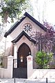 All Saints Moda Church (Anglican)
 -

-


References
- ^ "Kadıköy'den Apartman Öyküleri -2-: Sarıca Apartmanı". Gazete Kadıköy (in Turkish). Retrieved 9 September 2022.
- ^ a b "Çok kültürlü semt Moda'ya gitmek için 13 sebep (Moda neden bu kadar moda?)". NTV (in Turkish). 26 October 2016. Retrieved 9 September 2022.
- ^ "Kadıköylüler Moda İskelesi'ne kavuşuyor" (PDF). Gazete Kadıköy (in Turkish). 19 August 2022. Retrieved 9 September 2022.
- ^ a b c d e f g h i j k l m n Bedük, Ramazan. "Moda'nın 13 tarihi köşkü" (in Turkish). Bir İstanbul Hayali. Retrieved 12 September 2022.
- ^ "Moda Arif Sarıca Köşkü" (in Turkish). Turan Akıncı. Retrieved 12 September 2022.
Wikimedia Commons has media related to
Moda, Istanbul.