Miyoshi
三好市 | |
|---|---|
 Kazura Bridge, a popular sightseeing spot in Miyoshi | |
 Flag  Emblem | |
 Location of Miyoshi in Tokushima Prefecture | |
 Miyoshi Location in Japan | |
| Coordinates: 34°01′33.7″N 133°48′25.8″E / 34.026028°N 133.807167°E | |
| Country | Japan |
| Region | Shikoku |
| Prefecture | Tokushima |
| Government | |
| • Mayor | Miho Takai (since July 2021) |
| Area | |
| • Total | 721.42 km2 (278.54 sq mi) |
| Population (June 30, 2022) | |
| • Total | 23,782 |
| • Density | 33/km2 (85/sq mi) |
| Time zone | UTC+09:00 ( JST) |
| City hall address | Ikeda Shinmachi 1500-2, Miyoshi-shi, Tokushima-ken 778-8501 |
| Climate | Cfa |
| Website | Official website |
| Symbols | |
| Bird | Japanese white-eye |
| Flower | Habenaria radiata |
| Tree | Maple leaf |


Miyoshi (三好市, Miyoshi-shi) is a city located in Tokushima Prefecture, Japan. As of 30 June 2022 [update], the city had an estimated population of 23,782 in 12103 households and a population density of 33 persons per km2. [1] The total area of the city is 721.42 square kilometres (278.54 sq mi).
Geography
Miyoshi is located in the western part of Tokushima Prefecture and is the largest municipality on the island of Shikoku, accounting for 1/6 of the prefecture's geographic area. However, it is a very mountainous area with only 13% considered habitable. The Shikoku Mountains have many steep slopes and are subject to landslides and rockfalls. Traditional steep slope farming methods the used to prevent soil erosion. The Hashikura Prefectural Natural Park spans the border between Miyoshi and Higashimiyoshi.
Neighbouring municipalities
Tokushima Prefecture
Kagawa Prefecture
Ehime Prefecture
Kōchi Prefecture
Climate
Miyoshi has a humid subtropical climate ( Köppen climate classification Cfa) with hot summers and cool winters. Precipitation is high, but there is a pronounced difference between the wetter summers and drier winters. The average annual temperature in Miyoshi is 14.3 °C (57.7 °F). The average annual rainfall is 1,497.5 mm (58.96 in) with September as the wettest month. The temperatures are highest on average in August, at around 25.6 °C (78.1 °F), and lowest in January, at around 3.5 °C (38.3 °F). [2] The highest temperature ever recorded in Miyoshi was 37.1 °C (98.8 °F) on 16 July 1994; the coldest temperature ever recorded was −11.5 °C (11.3 °F) on 28 February 1981. [3]
| Climate data for Ikeda, Miyoshi (1991−2020 normals, extremes 1978−present) | |||||||||||||
|---|---|---|---|---|---|---|---|---|---|---|---|---|---|
| Month | Jan | Feb | Mar | Apr | May | Jun | Jul | Aug | Sep | Oct | Nov | Dec | Year |
| Record high °C (°F) | 18.8 (65.8) |
21.9 (71.4) |
24.4 (75.9) |
30.9 (87.6) |
32.4 (90.3) |
33.8 (92.8) |
37.1 (98.8) |
37.0 (98.6) |
35.2 (95.4) |
30.7 (87.3) |
26.5 (79.7) |
23.1 (73.6) |
37.1 (98.8) |
| Mean daily maximum °C (°F) | 8.0 (46.4) |
9.3 (48.7) |
13.3 (55.9) |
19.3 (66.7) |
24.1 (75.4) |
26.6 (79.9) |
30.5 (86.9) |
31.6 (88.9) |
27.3 (81.1) |
21.6 (70.9) |
15.9 (60.6) |
10.4 (50.7) |
19.8 (67.7) |
| Daily mean °C (°F) | 3.5 (38.3) |
4.2 (39.6) |
7.5 (45.5) |
13.0 (55.4) |
17.7 (63.9) |
21.2 (70.2) |
25.1 (77.2) |
25.6 (78.1) |
21.8 (71.2) |
16.0 (60.8) |
10.5 (50.9) |
5.6 (42.1) |
14.3 (57.8) |
| Mean daily minimum °C (°F) | −0.3 (31.5) |
−0.3 (31.5) |
2.3 (36.1) |
7.1 (44.8) |
12.0 (53.6) |
16.9 (62.4) |
21.1 (70.0) |
21.5 (70.7) |
17.8 (64.0) |
11.8 (53.2) |
6.1 (43.0) |
1.7 (35.1) |
9.8 (49.7) |
| Record low °C (°F) | −6.0 (21.2) |
−7.9 (17.8) |
−5.1 (22.8) |
−2.4 (27.7) |
2.3 (36.1) |
8.2 (46.8) |
13.6 (56.5) |
14.6 (58.3) |
7.5 (45.5) |
1.3 (34.3) |
−1.4 (29.5) |
−5.1 (22.8) |
−7.9 (17.8) |
| Average precipitation mm (inches) | 56.5 (2.22) |
60.9 (2.40) |
94.5 (3.72) |
86.1 (3.39) |
124.6 (4.91) |
197.6 (7.78) |
211.5 (8.33) |
169.2 (6.66) |
222.1 (8.74) |
136.8 (5.39) |
78.6 (3.09) |
84.6 (3.33) |
1,497.5 (58.96) |
| Average precipitation days (≥ 1.0 mm) | 9.9 | 10.0 | 11.9 | 10.0 | 9.8 | 12.6 | 11.9 | 10.3 | 11.0 | 9.2 | 8.7 | 10.8 | 126.1 |
| Mean monthly sunshine hours | 102.5 | 113.9 | 157.3 | 188.1 | 198.9 | 138.5 | 177.5 | 200.3 | 144.3 | 151.8 | 124.5 | 101.6 | 1,799.4 |
| Source: Japan Meteorological Agency [3] [2] | |||||||||||||
| Climate data for Higashiiyakyojo, Miyoshi (1991−2020 normals, extremes 1978−present) | |||||||||||||
|---|---|---|---|---|---|---|---|---|---|---|---|---|---|
| Month | Jan | Feb | Mar | Apr | May | Jun | Jul | Aug | Sep | Oct | Nov | Dec | Year |
| Record high °C (°F) | 17.9 (64.2) |
22.6 (72.7) |
23.7 (74.7) |
29.8 (85.6) |
31.6 (88.9) |
32.7 (90.9) |
35.7 (96.3) |
35.5 (95.9) |
33.4 (92.1) |
30.4 (86.7) |
24.4 (75.9) |
21.5 (70.7) |
35.7 (96.3) |
| Mean daily maximum °C (°F) | 6.5 (43.7) |
8.0 (46.4) |
12.3 (54.1) |
18.1 (64.6) |
22.6 (72.7) |
25.1 (77.2) |
28.8 (83.8) |
29.6 (85.3) |
25.8 (78.4) |
20.5 (68.9) |
15.0 (59.0) |
9.0 (48.2) |
18.4 (65.2) |
| Daily mean °C (°F) | 1.4 (34.5) |
2.4 (36.3) |
5.9 (42.6) |
11.1 (52.0) |
15.6 (60.1) |
19.1 (66.4) |
22.8 (73.0) |
23.2 (73.8) |
19.8 (67.6) |
14.1 (57.4) |
8.6 (47.5) |
3.5 (38.3) |
12.3 (54.1) |
| Mean daily minimum °C (°F) | −2.1 (28.2) |
−1.8 (28.8) |
0.8 (33.4) |
5.2 (41.4) |
9.7 (49.5) |
14.7 (58.5) |
18.7 (65.7) |
19.0 (66.2) |
15.7 (60.3) |
9.6 (49.3) |
4.0 (39.2) |
−0.3 (31.5) |
7.8 (46.0) |
| Record low °C (°F) | −10.6 (12.9) |
−11.5 (11.3) |
−7.7 (18.1) |
−3.8 (25.2) |
−0.6 (30.9) |
4.3 (39.7) |
9.1 (48.4) |
11.3 (52.3) |
5.4 (41.7) |
−0.3 (31.5) |
−2.9 (26.8) |
−8.7 (16.3) |
−11.5 (11.3) |
| Average precipitation mm (inches) | 81.2 (3.20) |
104.0 (4.09) |
142.9 (5.63) |
142.2 (5.60) |
177.9 (7.00) |
299.1 (11.78) |
414.1 (16.30) |
331.8 (13.06) |
356.0 (14.02) |
188.0 (7.40) |
103.3 (4.07) |
108.9 (4.29) |
2,437.3 (95.96) |
| Average precipitation days (≥ 1.0 mm) | 11.8 | 11.7 | 12.9 | 11.0 | 10.7 | 14.2 | 14.8 | 12.9 | 12.9 | 9.9 | 8.6 | 12.1 | 143.5 |
| Mean monthly sunshine hours | 94.3 | 109.1 | 151.4 | 188.8 | 199.6 | 141.8 | 166.2 | 174.7 | 136.4 | 149.6 | 118.9 | 98.3 | 1,732.3 |
| Source: Japan Meteorological Agency [4] [5] | |||||||||||||
Demographics
Per Japanese census data, the population of Miyoshi in 2020 is 23,605 people. [6] Miyoshi has been conducting censuses since 1920.
| Year | Pop. | ±% |
|---|---|---|
| 1920 | 61,689 | — |
| 1925 | 64,904 | +5.2% |
| 1930 | 64,922 | +0.0% |
| 1935 | 65,486 | +0.9% |
| 1940 | 63,080 | −3.7% |
| 1945 | 76,457 | +21.2% |
| 1950 | 77,702 | +1.6% |
| 1955 | 77,779 | +0.1% |
| 1960 | 71,370 | −8.2% |
| 1965 | 63,837 | −10.6% |
| 1970 | 55,537 | −13.0% |
| 1975 | 50,121 | −9.8% |
| 1980 | 47,057 | −6.1% |
| 1985 | 45,340 | −3.6% |
| 1990 | 42,219 | −6.9% |
| 1995 | 40,087 | −5.0% |
| 2000 | 37,305 | −6.9% |
| 2005 | 34,103 | −8.6% |
| 2010 | 29,963 | −12.1% |
| 2015 | 26,836 | −10.4% |
| 2020 | 23,605 | −12.0% |
| Miyoshi population statistics [6] | ||
History
As with all of Tokushima Prefecture, the area of Miyoshi was part of ancient Awa Province. From the Muromachi period it was the seat of the Miyoshi clan, a once powerful warlord clan who ruled most of Shikoku and parts of Honshu.. During the Edo period, the area was part of the holdings of Tokushima Domain ruled by the Hachisuka clan from their seat at Tokushima Castle. Following the Meiji restoration, it was organized into 10 villages within Miyoshi District, Tokushima with the creation of the modern municipalities system on October 1, 1889, including the villages of Ikeda (池田村), Mino (三野村), Sanmyo (三名村), and Minawa (三縄村). Ikeda was raised to town status on October 1, 1905 and Mino on January 26, 1924. Sanyo and Minawa merged on September 30, 1956 to form the town of Yamashiro.
The city of Miyoshi was established on March 1, 2006, from the merger between the towns of Ikeda, Ikawa, Mino and Yamashiro, (all from Miyoshi District) and the villages of Higashiiyayama and Nishiiyayama from Mima District.
Government
Miyoshi has a mayor-council form of government with a directly elected mayor and a unicameral city council of 22 members. Miyoshi contributes two members to the Tokushima Prefectural Assembly. In terms of national politics, the city is part of Tokushima 2nd district of the lower house of the Diet of Japan.
Economy
The economy of Miyoshi is strongly dependent on agriculture, forestry and small-scale food processing.
Education
Miyoshi has 13 public elementary schools and six public middle schools operated by the city government and three public high schools operated by the Tokushima Prefectural Department of Education. The prefecture also operates one special education school for the handicapped.
Transportation
Railway
![]() Shikoku Railway Company –
Tokushima Line
Shikoku Railway Company –
Tokushima Line
![]() Shikoku Railway Company –
Dosan Line
Shikoku Railway Company –
Dosan Line
Highways
 Tokushima Expressway
 National Route 32
 National Route 192
 National Route 319
 National Route 438
 National Route 439
Sister city relations
-
 The Dalles,
Oregon, United States
The Dalles,
Oregon, United States
Local attractions
- Unpen-ji, 66th temple on the Shikoku Pilgrimage
- Hashikura Prefectural Natural Park
- Iya Valley
- Kazura Bridge
- Oku Kazura Bridge
- Oboke Gorge
- Koboke Gorge
- Yoshino River
-
 Hasikura Ropeway
 -
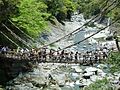 Kazura-bashi, Iya Valley
 -
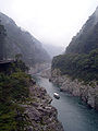 Oboke Koboke
 -
 Hashikura-ji


Noted people from Miyoshi
- Miho Takai, politician
- Shunichi Yamaguchi, politician
- Kikuji Yamashita, artist
References
- ^ "Miyoshi city official statistics" (in Japanese). Japan.
- ^ a b 気象庁 / 平年値(年・月ごとの値). JMA. Retrieved April 14, 2022.
- ^ a b 観測史上1~10位の値(年間を通じての値). JMA. Retrieved April 14, 2022.
- ^ 観測史上1~10位の値(年間を通じての値). JMA. Retrieved April 14, 2022.
- ^ 気象庁 / 平年値(年・月ごとの値). JMA. Retrieved April 14, 2022.
- ^ a b Miyoshi population statistics
External links
-
 Media related to
Miyoshi, Tokushima at Wikimedia Commons
Media related to
Miyoshi, Tokushima at Wikimedia Commons
- Miyoshi City official website (in Japanese)
- miyoshi-tourism (in English)
| Cities | |
|---|---|
| Districts | |
| International | |
|---|---|
| National | |
| Geographic | |
|
| This Tokushima location article is a stub. You can help Wikipedia by expanding it. |