Miyoshi
三次市 | |
|---|---|
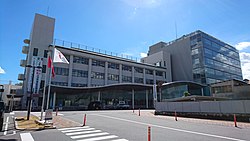
 Miyoshi City Hall | |
|
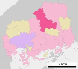
Location of Miyoshi in Hiroshima Prefecture | |
 | |
| Coordinates: 34°48′N 132°51′E / 34.800°N 132.850°E | |
| Country | Japan |
| Region | Chūgoku ( San'yō) |
| Prefecture | Hiroshima |
| Government | |
| • Mayor | Kazutoshi Masuda (since May 2011) |
| Area | |
| • Total | 778.14 km2 (300.44 sq mi) |
| Population (March 31, 2023) | |
| • Total | 49,106 |
| • Density | 63/km2 (160/sq mi) |
| Time zone | UTC+09:00 ( JST) |
| City hall address | 2-8-1, Tōkaichi Naka, Miyoshi-shi, Hiroshima-ken 728-8501 |
| Climate | Cfa |
| Website |
www |
| Symbols | |
| Bird | Japanese wagtail |
| Flower | Sakura |
| Tree | Maple |


Miyoshi (三次市, Miyoshi-shi) is a city located in Hiroshima Prefecture, Japan. As of 31 March 2023 [update], the city had an estimated population of 49,106 in 23154 households and a population density of 63 persons per km². [1] The total area of the city is 778.14 square kilometres (300.44 sq mi).
Geography
Miyoshi is located almost in the middle of the Chugoku region, with the Chugoku Mountains to the north and a flat agricultural area to the south. Together with the neighboring city of Shōbara, it forms the northern part of the prefecture called the "Bihoku region". Because the tributaries of the Enokawa River meet at the Miyoshi Basin, it prospered as a river port and has long functioned as a strategic point for culture, economy, and transportation connecting the San'in and San'yō regions. About one-third of the rain that falls in Hiroshima Prefecture is collected here, and it has abundant water. Due to the confluence of rivers, fog tends to occur in this area from late autumn to early spring. The center of urban area is the Miyoshi Basin, which is located between the Chugoku Mountains and the Kibi Plateau at an elevation of 150 to 250 meters. Miyoshi developed as a twin settlement, with "Itsukaichi", as the castle town of the Miyoshi clan towards the west, and the current city center district where Miyoshi Station is located as a market town called 'Tokaichi-machi' to the east.
Adjoining municipalities
Climate
Miyoshi has a humid subtropical climate ( Köppen climate classification Cfa) characterized by cool to mild winters and hot, humid summers. The average annual temperature in Miyoshi is 13.5 °C (56.3 °F). The average annual rainfall is 1,467.0 mm (57.76 in) with July as the wettest month. The temperatures are highest on average in August, at around 25.9 °C (78.6 °F), and lowest in January, at around 1.9 °C (35.4 °F). [2] The highest temperature ever recorded in Miyoshi was 37.9 °C (100.2 °F) on 16 July 2018; the coldest temperature ever recorded was −12.5 °C (9.5 °F) on 27 February 1981. [3]
| Climate data for Miyoshi (1991−2020 normals, extremes 1978−present) | |||||||||||||
|---|---|---|---|---|---|---|---|---|---|---|---|---|---|
| Month | Jan | Feb | Mar | Apr | May | Jun | Jul | Aug | Sep | Oct | Nov | Dec | Year |
| Record high °C (°F) | 16.6 (61.9) |
21.1 (70.0) |
24.8 (76.6) |
31.1 (88.0) |
33.3 (91.9) |
35.2 (95.4) |
37.9 (100.2) |
37.8 (100.0) |
36.9 (98.4) |
30.4 (86.7) |
25.7 (78.3) |
18.9 (66.0) |
37.9 (100.2) |
| Mean daily maximum °C (°F) | 6.8 (44.2) |
8.4 (47.1) |
13.0 (55.4) |
19.3 (66.7) |
24.3 (75.7) |
27.1 (80.8) |
30.6 (87.1) |
32.1 (89.8) |
27.6 (81.7) |
21.8 (71.2) |
15.5 (59.9) |
9.0 (48.2) |
19.6 (67.3) |
| Daily mean °C (°F) | 1.9 (35.4) |
2.8 (37.0) |
6.3 (43.3) |
11.9 (53.4) |
17.1 (62.8) |
21.2 (70.2) |
25.1 (77.2) |
25.9 (78.6) |
21.6 (70.9) |
15.1 (59.2) |
9.0 (48.2) |
3.9 (39.0) |
13.5 (56.3) |
| Mean daily minimum °C (°F) | −1.4 (29.5) |
−1.3 (29.7) |
0.9 (33.6) |
5.2 (41.4) |
10.7 (51.3) |
16.4 (61.5) |
21.0 (69.8) |
21.6 (70.9) |
17.3 (63.1) |
10.6 (51.1) |
4.7 (40.5) |
0.5 (32.9) |
8.9 (47.9) |
| Record low °C (°F) | −10.8 (12.6) |
−12.5 (9.5) |
−7.5 (18.5) |
−3.6 (25.5) |
0.2 (32.4) |
7.2 (45.0) |
10.7 (51.3) |
13.2 (55.8) |
5.7 (42.3) |
0.5 (32.9) |
−2.3 (27.9) |
−10.2 (13.6) |
−12.5 (9.5) |
| Average precipitation mm (inches) | 74.2 (2.92) |
73.0 (2.87) |
103.5 (4.07) |
104.4 (4.11) |
135.8 (5.35) |
186.1 (7.33) |
245.5 (9.67) |
141.9 (5.59) |
162.5 (6.40) |
94.3 (3.71) |
68.8 (2.71) |
83.9 (3.30) |
1,467 (57.76) |
| Average precipitation days (≥ 1.0 mm) | 13.0 | 11.4 | 11.9 | 9.6 | 9.6 | 11.9 | 12.2 | 9.8 | 9.6 | 7.5 | 8.7 | 12.7 | 127.9 |
| Mean monthly sunshine hours | 85.7 | 105.7 | 149.0 | 177.6 | 198.9 | 146.7 | 158.8 | 187.6 | 140.6 | 134.4 | 105.5 | 82.0 | 1,675.1 |
| Source: Japan Meteorological Agency [2] [3] | |||||||||||||
Demographics
Per Japanese census data, the population of Miyoshi in 2020 is 50,681 people. [4] Miyoshi has been conducting censuses since 1950.
| Year | Pop. | ±% |
|---|---|---|
| 1950 | 93,411 | — |
| 1955 | 89,216 | −4.5% |
| 1960 | 83,030 | −6.9% |
| 1965 | 71,708 | −13.6% |
| 1970 | 65,561 | −8.6% |
| 1975 | 64,190 | −2.1% |
| 1980 | 63,582 | −0.9% |
| 1985 | 64,089 | +0.8% |
| 1990 | 63,596 | −0.8% |
| 1995 | 62,910 | −1.1% |
| 2000 | 61,635 | −2.0% |
| 2005 | 59,314 | −3.8% |
| 2010 | 56,613 | −4.6% |
| 2015 | 53,615 | −5.3% |
| 2020 | 50,681 | −5.5% |
| Miyoshi population statistics [4] | ||
History
The area of Miyoshi was part on ancient Bingo Province. During then Edo Period, it was largely the territory of Hiroshima Domain. Following the Meiji restoration, the town of Miyoshi was established with the creation of the modern municipalities system on April 1, 1889. Miyoshi was raised to city status on March 31, 1954.
On April 1, 2004, Miyoshi absorbed the towns of Kisa, Mirasaka and Miwa, the villages of Funo, Kimita and Sakugi (all from Futami District), and the town of Kōnu (from Kōnu District) to create the new and expanded city of Miyoshi. Futami District was dissolved as a result of this merger.
Government
Miyoshi has a mayor-council form of government with a directly elected mayor and a unicameral city council of 24 members. Miyoshi contributes one member to the Hiroshima Prefectural Assembly. In terms of national politics, the city is part of the Hiroshima 5th district of the lower house of the Diet of Japan.
Economy
The economy of Miyoshi is largely agricultural, with grapes and wineries predominant. Light manufacturing is centered on automobile engines and components for Mazda, which also has its test and proving grounds located in the city.
Education
Miyoshi has 22 public elementary schools, 12 public junior high schools and one public high school operated by the city government, and three public high school operated by the Hiroshima Prefectural Board of Education. The prefecture also operates one special education school for the disabled.
Transportation
Railway
![]() JR West (JR West) -
Geibi Line
JR West (JR West) -
Geibi Line
- Shimowachi - Shiomachi - Kamisugi - Yatsugi - Miyoshi - Nishi-Miyoshi - Shiwachi - Kamikawatachi
![]() JR West (JR West) -
Fukuen Line
JR West (JR West) -
Fukuen Line
- Kōnu - Kajita - Bingo-Yasuda - Kisa - Mirasaka - Shiomachi - Kamisugi - Yatsugi - Miyoshi
Highways
 Chūgoku Expressway
 Onomichi Expressway
 Matsue Expressway
 National Route 54
 National Route 183
 National Route 184
 National Route 375
 National Route 433
 National Route 434
Sister city relations
-
 -
Ya'an,
Sichuan, China, since October 6, 1992
 -
 -
Americus, Georgia, United States, since May 18,1995
 -
 -
Sacheon,
South Gyeongsang Province South Korea, since May 24, 2001
Notable people from Miyoshi
- Daisuke Nishio, animator and movie director
References
- ^ "Miyoshi city official statistics" (in Japanese). Japan.
- ^ a b 気象庁 / 平年値(年・月ごとの値). JMA. Retrieved May 15, 2022.
- ^ a b 観測史上1~10位の値(年間を通じての値). JMA. Retrieved May 15, 2022.
- ^ a b Miyoshi population statistics
External links
- Miyoshi City official website (in Japanese)


