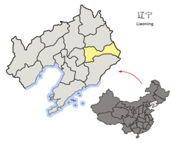
Mingshan District
明山区 | |
|---|---|
 Mingshan in Benxi | |
 Benxi in Liaoning | |
| Coordinates: 41°18′30″N 123°49′03″E / 41.30833°N 123.81750°E | |
| Country | People's Republic of China |
| Province | Liaoning |
| Prefecture-level city | Benxi |
| Time zone | UTC+8 ( China Standard) |
Mingshan District ( simplified Chinese: 明山区; traditional Chinese: 明山區; pinyin: Míngshān Qū) is a district under the administration of the city of Benxi, Liaoning Province, China. It has a total area of 410 square kilometres (160 sq mi), and a population of approximately 300,000 as of 2002.
Administrative divisions
There are seven subdistricts and two towns in the district. [1]
- Jinshan Subdistrict ( Chinese: 金山街道; pinyin: Jīnshān jiēdào)
- Dongxing Subdistrict ( simplified Chinese: 东兴街道; traditional Chinese: 東興街道; pinyin: Dōngxìng jiēdào)
- Xinming Subdistrict (新明街道; Xīnmíng jiēdào)
- Gaoyu Subdistrict (高峪街道; Gāoyù jiēdào)
- Mingshan Subdistrict (明山街道; Míngshān jiēdào)
- Niuxintai Subdistrict (牛心台街道; 牛心臺街道; Niúxīntái jiēdào)
- Beidi Subdistrict (北地街道; Běidì jiēdào)
References
External links
- Mingshan District Government official website (in Chinese)