Millville, New Jersey | |
|---|---|
 Montague Grange No. 140 | |
 Millville  Millville  Millville | |
| Coordinates: 41°18′47″N 74°46′48″W / 41.31306°N 74.78000°W [1] | |
| Country | |
| State | |
| County | Sussex |
| Township | Montague |
| GNIS feature ID | 878391 [1] |
Millville is an unincorporated community located along River Road ( County Route 521) and Shimers Brook in Montague Township of Sussex County, New Jersey. [1] [2] The Montague Grange and other parts of the community are in the Delaware Water Gap National Recreation Area. [3]
History
The community got its name from the gristmills and sawmills built along Shimers Brook, then known as Chambers Mill Brook, [4] starting in 1722. During the American Revolutionary War, Captains Abram Shimer and James Bonell were at the fort located here to protect the mills. [5] Shimer built a mill here c. 1750. [6] In the 1790s, Jacob Shimer, his son, built a house on Old Mine Road, now River Road. It was documented by the Historic American Buildings Survey in 1970, before being demolished by 1980. [7]
Historic district
Millville Historic and Archaeological District | |
| Area | 9.3 acres (3.8 ha) |
|---|---|
| NRHP reference No. | 84002807 [8] |
| NJRHP No. | 2606; 5172 [9] |
| Significant dates | |
| Added to NRHP | January 30, 1984 |
| Designated NJRHP | November 21, 1983 November 21, 2013 |
The Millville Historic and Archaeological District is a 9.3-acre (3.8 ha) historic district encompassing the village. It was added to the National Register of Historic Places on January 30, 1984, for its significance in exploration/settlement, history, and industry. The district includes four contributing buildings and six contributing sites. [8] The district boundary on the state register was increased on November 21, 2013, and lists River Road ( County Route 521), Clove Road ( County Route 653), Millville and Weider Roads. [9] The county has posted a historical information sign on Clove Road. [5]
-
 House built 1749 by Captain Abram Shimer on River Road
 -
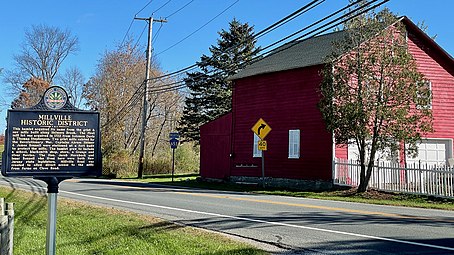 Historical information sign at the Bonnell–Westbrook wagon house on Clove Road


See also
References
- ^ a b c "Millville". Geographic Names Information System. United States Geological Survey, United States Department of the Interior.
- ^ "Locality Search". State of New Jersey.
-
^
"Delaware Water Gap National Recreation Area: Scenic Drives".
National Park Service.
Montague Grange
- ^ "Shimers Brook". Geographic Names Information System. United States Geological Survey, United States Department of the Interior. Variant name: Chambers Mill Brook
- ^ a b "Millville Historic District". Sussex County, New Jersey.
- ^ Snell, James P.; Clayton, W.W. (1881). "Millville and early mills". History of Sussex and Warren Counties, New Jersey, with Illustrations and Biographical Sketches of its Prominent Men and Pioneers. Philadelphia: Everts & Peck. p. 368. OCLC 14075041.
- ^ "Jacob Shimer House, Old Mine Road, Millville, Sussex County, NJ". Historic American Buildings Survey. 1970.
- ^ a b "National Register Information System – Millville Historic and Archaeological District (#84002807)". National Register of Historic Places. National Park Service. November 2, 2013.
- ^
a
b
"New Jersey and National Registers of Historic Places – Sussex County" (PDF).
New Jersey Department of Environmental Protection – Historic Preservation Office. September 28, 2021. p. 4.
Millville Historic and Archaeological District (Boundary Increase and Additional Documentation)
External links
-
 Media related to
Millville, Sussex County, New Jersey at Wikimedia Commons
Media related to
Millville, Sussex County, New Jersey at Wikimedia Commons - Historic American Buildings Survey (HABS) No. NJ-818, " Jacob Shimer House, Old Mine Road, Millville, Sussex County, NJ", 5 photos, 4 measured drawings, 7 data pages, 1 photo caption page
- "Millville Historic District". Historical Marker Database.

Municipalities and communities of
Sussex County, New Jersey, United States | ||
|---|---|---|
| Boroughs |  | |
| Town | ||
| Townships | ||
| CDPs | ||
|
Other communities | ||
| Footnotes | ‡This populated place also has portions in an adjacent county or counties | |
| Landmarks | ||
|---|---|---|
| Districts |
| |
|
Places of worship | ||
| Houses | ||
| Buildings | ||
| Sites | ||
| Structures | ||