Milledgeville Historic District | |
 Former Baldwin County Courthouse - September 2018 | |
  | |
| Location | Bounded by Irwin, Thomas, and Warren Sts. and Fishing Creek, Milledgeville, Georgia |
|---|---|
| Coordinates | 33°04′42″N 83°13′43″W / 33.078333°N 83.228611°W |
| Area | 3,240 acres (1,310 ha) |
| Built | 1839 |
| Architect | Multiple |
| Architectural style | Classical Revival |
| NRHP reference No. | 72000360 [1] |
| Added to NRHP | June 28, 1972 |
The Milledgeville Historic District, in Milledgeville in Baldwin County, Georgia, is a historic district which was listed on the National Register of Historic Places in 1972. [1]
The district is approximately the size of the 3,240 acres (13.1 km2) area laid out in the 1803 plan for the city. [2]
It includes Classical Revival and other architecture. [2]
It includes at least two properties that are separately listed on the National Register:
- Atkinson Hall, Georgia College, and
- Old Governor's Mansion (1839), 120 South Clarke St.
Gallery
-
 U.S. Post Office
 -
 201 N. Wayne
 -
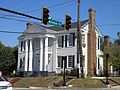
 501 West Mcintosh


References
- ^ a b "National Register Information System". National Register of Historic Places. National Park Service. July 9, 2010.
- ^ a b William R. Mitchell, Jr. (May 25, 1972). "National Register of Historic Places Inventory/Nomination: Milledgeville Historic District". National Park Service. Retrieved April 27, 2017. With 34 photos from 1972.
External links
-
 Media related to
Milledgeville Historic District at Wikimedia Commons
Media related to
Milledgeville Historic District at Wikimedia Commons
| Topics | |
|---|---|
| Lists by state |
|
| Lists by insular areas | |
| Lists by associated state | |
| Other areas | |
| Related | |